180 km
Of priority corridors; up to 360 km of sidewalk if both sides are treated.
60 towns
Candidate towns in all 25 districts and 9 provinces.
Rs 41.7 bn
It costs about Rs 41.7 billion over five years at 2026 prices.
10 pilots first
Ten pilots go first, and nothing scales until they have been through a monsoon.

Before the numbers
Seven people will not come home today.
That is the daily average on Sri Lanka’s roads. In 2025 the police counted 2,732 deaths. Of those, 857 were people on foot: more than two every day, walking to a shop, a school gate or a bus.S01
Walk the main street of almost any town and the reason is in front of you. The shops open straight onto the traffic. The drain is half covered. Motorcycles park where a pavement should be, so a mother with a child steps into the lane and trusts the bus behind her to see them.
The Inspector General of Police said it plainly in September 2026: many of the pedestrians who die are simply walking or standing at the roadside.S12 Nobody in that sentence was doing anything wrong. The street gave them nowhere else to be.
This proposal asks for something modest and concrete. Pick 60 towns. In each one, build a continuous, level, shaded sidewalk through the centre, with crossings where people already cross, bus stops that do not block the path, drains that work, and shopfronts that stay local but stop spilling into the walkway.
Start with ten one-kilometre pilots. Measure them honestly. Then scale what survives a monsoon and a festival season.
It costs about Rs 41.7 billion over five years at 2026 prices. For scale, the 2027 Budget presented on 12 November 2026 puts about Rs 487 billion into roads and railways in a single year.S14 The average yearly cost of this programme is about 1.7% of that.
Roads move vehicles. Streets hold a town together. Sri Lanka has spent a generation on the first. This is a plan for the second.
The decision requested
Approve the preparation, fund the pilots, release the rest in stages
60
candidate towns in all 25 districts and 9 provinces
180 km
of priority corridors; up to 360 km of sidewalk if both sides are treated
Rs 3.1 bn
first release: preparation and ten 1 km pilots
Rs 552 m
a year for upkeep once everything is built
What government is asked to approve
Preparation of a national town street safety programme, and a conditional first release. Construction money for each later wave is released only after surveys, independently checked designs, priced quantities and a signed maintenance agreement.
The aim in each town is a usable walking network through the centre. It is not a rebuild of every road.
The one design rule
A clear walking path of 2.4 m in busy commercial streets. Trees, poles, parking and shop displays sit outside it. Everything else in this document serves that rule.
Why now
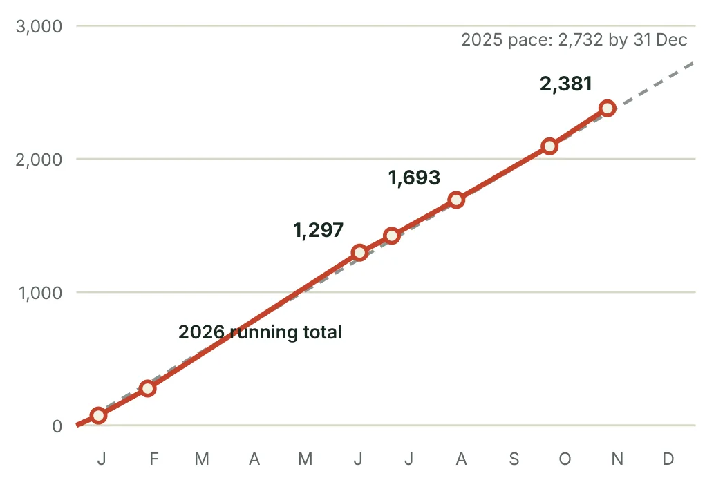
2026 is running at the same pace as 2025: 2,381 deaths by the second week of November.S11 The police have mapped 712 accident-prone locations, and government has set aside Rs 1.5 billion to fix dangerous spots on local roads.S12 S13 The 2027 Budget puts Rs 22 billion into widening and improving selected roads for congestion and safety.S14 The money and the attention exist. What is missing is a standard for the part of the road where people walk.
What approval does not mean
The 60 towns are a proposed coverage list, not a crash ranking. Corridor lengths are planning allowances. This document authorises no land acquisition, no contract award, no forced change to any shopfront and no road closure.
If money is short, cut facade grants and optional landscaping first. Never cut drainage, accessible crossings, clear width or maintenance.
How to read this proposal
Four labels
- Verified fact. A figure traceable to a named source in the register.
- Evidence from abroad. A finding from another country. Useful, but not a prediction for Sri Lanka.
- Proposal. A design or policy choice this document recommends.
- Planning assumption. An input used to make the cost or schedule reviewable. It must be replaced by survey or tender evidence.
What this document is not
It is a researched concept proposal built from public sources. It is not a feasibility study. It includes no site visits, no topographic survey, no utility investigation, no contractor quotations and no crash-location database.
No national inventory of sidewalks was found in the sources reviewed. So this document does not claim that towns outside Colombo have no sidewalks. Many have some. Few have a continuous one.
The dimensions in Part 2 are proposed programme criteria informed by international and Singapore guidance. They are not presented as current Sri Lankan statutory minimums.
Source references appear as numbered tags such as S01. The register at the back gives the institution, document, date and link for each.
Part 1: The case
Sri Lanka loses a busload of people on its roads every week. Nearly a third are on foot.
A country of 21.8 million lost 2,732 people on the road in one year
2,732
people killed
7.5
deaths a day
12.5
deaths per 100,000 people
31%
were pedestrians
| 2025 police measure | Number | What it counts |
|---|---|---|
| All reported crashes | 22,153 | Reported events, not every collision |
| Fatal crashes | 2,583 | Crashes causing death, not people |
| Serious crashes | 5,276 | A severity class, not people injured |
| Minor crashes | 10,067 | A severity class |
| Damage only | 4,227 | Property damage events |
| People killed | 2,732 | The headline |
Verified fact. Sri Lanka Police summary for 1 January to 31 December 2025. The four crash classes add up exactly to 22,153.S01 S02
The rate uses the final 2024 census population of 21,781,800.S04 It sits close to the World Health Organization estimate of 11.5 per 100,000 for 2021, so the scale of the problem is not in doubt even where individual counts differ.S24
Between 2020 and 2024 the police recorded 118,697 crashes and 12,322 deaths, an average of about 2,464 deaths a year. 2025 was roughly 11% above that five-year average.S02
These are deaths only. For every person killed, about two crashes were classed as serious. Families lose an income, a carer or a child, and the hospital bill arrives either way.
One caution before going further: the police have published three different 2025 totals. This proposal uses the summary report figure and explains the others on page 9.
People on foot and on two wheels carry most of the loss
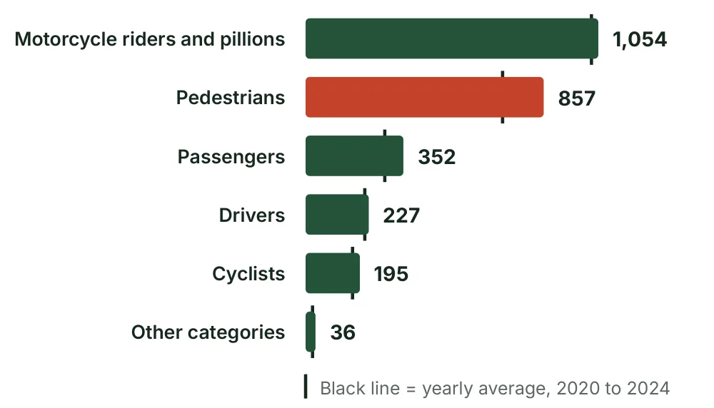
857 pedestrians died in 2025. The average for the five years before was 709.S03 That is about 21% above the 2020 to 2024 yearly average.
Pedestrians and motorcyclists together account for about 70% of all deaths. A programme that protects people outside cars is aimed at the centre of the problem, not its edge.
The published categories add up to 2,721, which is 11 fewer than the 2,732 headline. The gap is left visible here. It should be clarified with the police, not quietly assigned to a category.
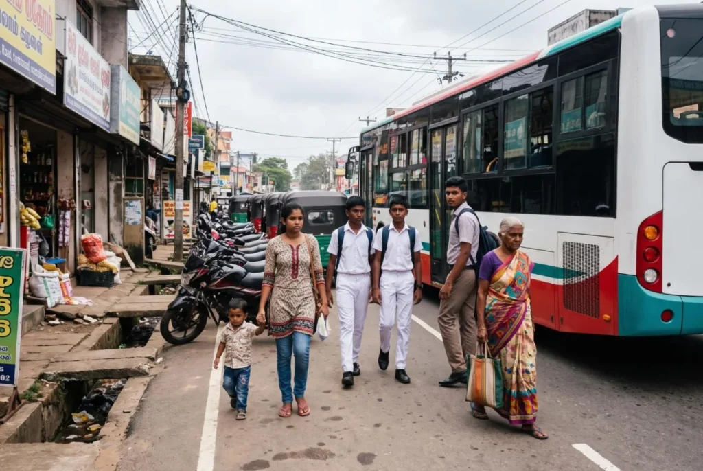
Sidewalks alone will not fix this. Pedestrian works must sit beside motorcycle safety, safer buses, vehicle checks, enforcement and emergency care. But sidewalks are the one piece no agency currently owns as a national standard.
This year is tracking last year almost death for death
| Killed by 13 August 2026 | Deaths |
|---|---|
| Motorcycle riders | 603 |
| Pedestrians | 555 |
| Passengers | 162 |
| Drivers | 136 |
| Pillion riders | 119 |
| Cyclists | 115 |
| All road users | 1,693 |
Listed groups add up to 1,690; three deaths fall outside them.S09
By 10 November the police had counted 2,381 deaths in 2,257 fatal crashes. That is about 7.6 a day, against 7.5 a day across 2025. In September the Inspector General said deaths were 16 higher than at the same point last year.S11 S12
Pedestrians were 555 of the first 1,693 deaths, or about 33%. Motorcyclists have overtaken them as the largest single group this year.S09
What government has already done in 2026
- 712 accident-prone locations identified by a nationwide police survey and passed to road authorities.S12
- Rs 1.5 billion to fix dangerous spots on roads outside the national network, Rs 60 million per district.S13
- Budget 2027: Rs 22 billion for widening and improving selected roads for congestion and safety, and Rs 1.5 billion for a driver demerit point system.S14 S15
Spot fixes treat the places where people have already died. A sidewalk standard treats the whole street before they do. The two belong together.
A later media report of the November statement gives a pedestrian count far below the August figure. It cannot be correct as a running total and is not used here.
What the numbers can prove, and what they cannot
| Source and period | Deaths | How this proposal uses it |
|---|---|---|
| Police summary report, full year 2025S01 | 2,732 | Primary headline |
| Police statement, 2 January 2026S06 | 2,710 | Early reported count; the reason it differs from later totals is not confirmed |
| Police briefing, 12 February 2026S05 | 2,746 | A later revision; not reconciled with the summary report |
| Planning programme series, 2024S22 | 2,368 | Official comparator; conflicts with the row below |
| NDDCB handbook series, 2024S23 | 2,521 | Matches the February police briefing for 2024 |
| WHO estimate, 2021S24 | 2,513 | Different year and method |
The three 2025 figures differ by 36 deaths, or 1.3%. That does not change any conclusion here. The 2024 figures differ by more, so this proposal does not publish a precise 2024 to 2025 growth rate. The Ministry and the police should agree one reporting window, one follow-up period for deaths in hospital, and one revision rule before issuing a national trend.
Missing sidewalks are a credible cause, not a measured one
A person forced into a live lane has no separation from traffic. Parked vehicles hide them. Buses stop wherever passengers wave. Turning vehicles cut across them. These mechanisms are visible in any town. What nobody has measured is how many Sri Lankan deaths each one explains.
Evidence from abroad. The US Federal Highway Administration reports that sidewalks are associated with 65 to 89% fewer crashes involving people walking along a road.S26 That applies to one crash type in the studies behind it. It must not be applied to all pedestrian deaths, or used to forecast lives saved by this programme.
The local evidence each corridor needs
At least three years of geocoded fatal and serious crashes. Pedestrian counts. Measured speeds. Road geometry. Police and hospital records linked where the law allows. Walking-along, crossing, turning, bus-stop and night-time cases recorded separately.
Photograph the gaps and the obstruction points, not just the lengths of pavement that exist.
Results must be compared with similar untreated corridors, allowing for changes in footfall and traffic. Do not choose sites only because of one unusually bad year. A site picked because of one terrible year will look better the next year whatever is built. That is chance, not success.
One strip of land is doing six jobs at once
A town main street carries through traffic, serves shops, takes buses and three-wheelers, receives deliveries and lets people cross. The usual failure is not a lack of road. It is that nobody has decided who gets which part of it. Adding vehicle capacity alone can leave the most exposed users with nowhere safe to stand or walk.
| What you see on the street | What to do about it |
|---|---|
| The walking route is missing, broken or blocked | A continuous accessible route on both sides; remove or move the obstructions |
| Vehicles park on the road edge | Marked parking pockets, time limits and agreements for off-street lots |
| People cross between parked vehicles | Clear sightlines, kerb extensions and crossings where people already walk |
| Buses stop wherever they are waved down | Defined stops with boarding areas, agreed with operators |
| Fast traffic enters the shopping area | A gateway treatment and an engineered low-speed town zone |
| Open drains or loose covers | Drainage checked for capacity, with load-rated, accessible covers |
| Shop floors and private ramps cut into the path | Keep the public path level; solve each entrance inside the frontage strip |
A main road is not an expressway
An A or B road can run straight through a town and serve every shop on it. It needs crossings at street level, designed for its real speed, visibility and lane count. Expressways are a different thing: the Road Development Authority bars pedestrians and slow vehicles from them, and they should never gain zebra crossings or shop access.S33
The order of work
First settle the right of way and the drainage. Then give walking and crossing their space. Then slow the conflict points. Then organise buses and deliveries. Parking fits into what is left. Planting and shopfronts come last, on top of a street that already works. Keep the option of a future bypass or transport project open, but do not make the current safety work wait for it.
Singapore lens
Singapore’s housing towns were planned with this order built in: walking routes and drains first, then roads, then parking in dedicated lots. Sri Lankan towns grew the other way round, so the work here is retrofit. That is harder, but the order of priority is the same.
Part 2: The street
A sidewalk is not a strip of paving. It is a promise that a person can get from one end of town to the other without stepping into traffic.
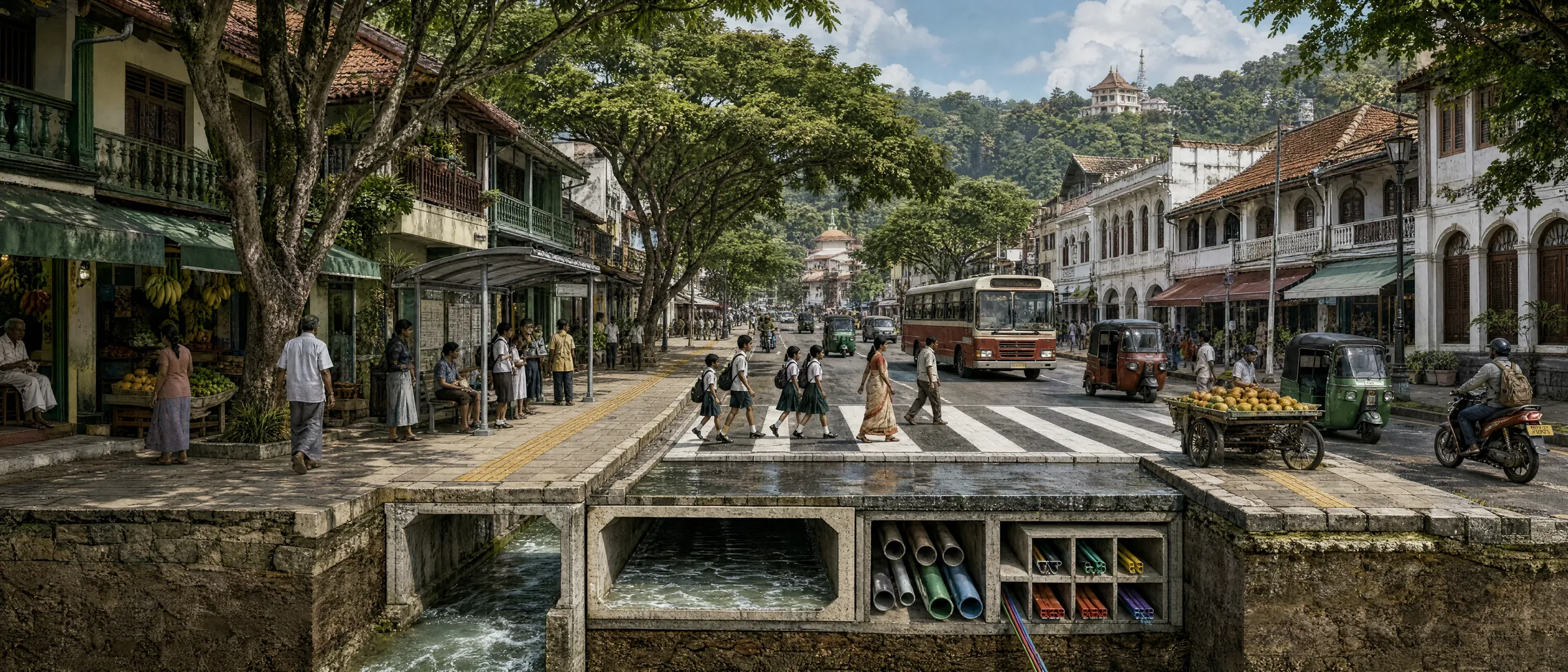
Anatomy of a safe town street
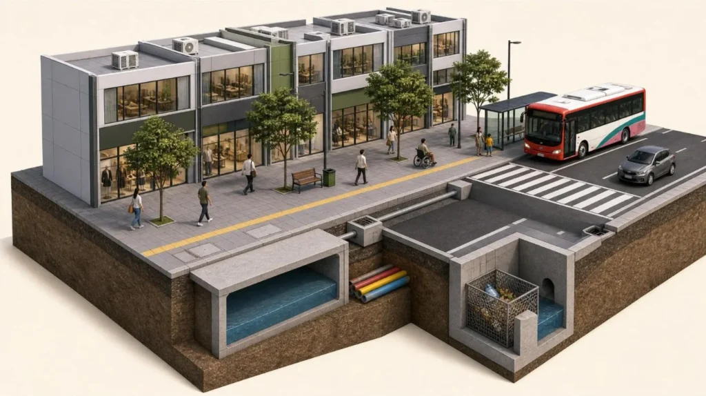
- A clear path of 2.4 m
Nothing stands in it: no pole, no step, no display, no parked motorcycle. - A frontage strip
0.3 to 0.6 m where shop steps, doors and goods belong. - A tree and furniture strip
Shade, lights, bins, benches and signs, all in one line outside the path. - A raised crossing
Level with the sidewalk, on the line people already walk, with a 30 km/h street around it. - Tactile paving
Warning and guidance surfaces, with approved patterns, direction and placement used the same way in every town. - A bus stop that fits the bus
A raised kerb for low-floor boarding, with the shelter behind the path. - A drain that works
Closed under the sidewalk, fed by small inlets at the road edge, with a litter trap downstream. - Ducts below
Shared ducts laid once, so cables can go underground without breaking the paving. - Shopfronts in one band
Each shop keeps its name; signs, awnings and cables line up. - Someone responsible
A named owner and a funded crew for every drain, light, tree and bin.
Measure the space a person can actually walk through
A sidewalk drawn 3 m wide can hold a tree pit, a set of steps and an electricity pole, and leave a wheelchair user with nothing. The only width that counts is the clear width between obstructions.
| Element | Proposed criterion | How to apply it |
|---|---|---|
| Clear path, busy commercial street | 2.4 m minimum target; 3.0 m or more at busy nodes | Widen for measured crowds and queues |
| Clear path, quieter constrained street | 1.8 m continuous | An exception, assessed with disabled users |
| Short unavoidable pinch point | 1.5 m, by documented exception only | Never a town standard; give a passing place |
| Frontage strip | 0.3 to 0.6 m | Doors, steps and displays; more where shops trade outside |
| Furniture and tree strip | 0.8 to 1.5 m | Outside the clear path; large trees need more root space |
| Crossfall | 1 to 2%; no more than 2% | Drains water without tipping a wheelchair |
| Gradient along the path | No steeper than 1:20 where possible | Hill towns need a designed accessible route |
| Kerb ramp | 1:15 to 1:20 preferred; 1:12 maximum | Level landing at the top; no twisted ramps |
| Headroom | At least 2.3 m | Check awnings, signs and branches |
Proposal. Criteria informed by the Global Street Design Guide, which recommends 2.4 to 4.5 m clear in busy commercial streets, and by UK inclusive mobility guidance.S27 S28 The 2006 accessibility regulations are part of the Sri Lankan legal baseline.S30 S31
Singapore lens
Singapore writes two numbers for every public walkway: the overall width and the clear width. Near MRT stations a covered walkway must be 3.6 m overall and 3.0 m clear. Between 200 and 400 m from a station it is 3.0 m and 2.4 m. Everywhere else it is 2.4 m and 2.0 m.S55 Its 2025 accessibility code sets accessible routes at 1.5 m or 1.8 m depending on building type.S56 The 2.4 m target proposed here for busy Sri Lankan streets matches Singapore’s middle tier.
When the width is not there, the answer is to remove parking, combine utility poles, change the traffic circulation or agree a small frontage setback. It is never to shrink the walking path and hope nobody in a wheelchair comes by.
Busy bus stops and market entrances need a pedestrian capacity check, not just a minimum dimension.
Four layouts that fit the towns Sri Lanka already has
A · Two-way commercial street · 14.5 m wall to wall
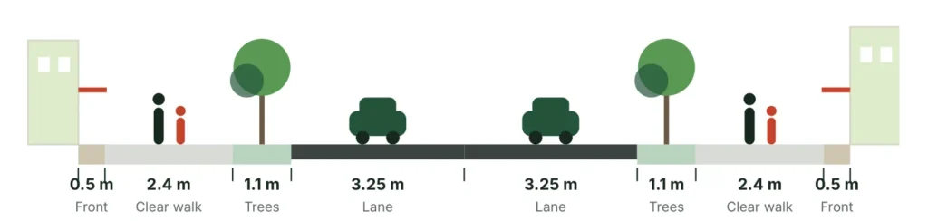
A 4.0 m sidewalk on each side and two 3.25 m lanes. No continuous parking: pockets and loading bays need extra width or a local change of section.
B · Constrained two-way street · 10.2 m
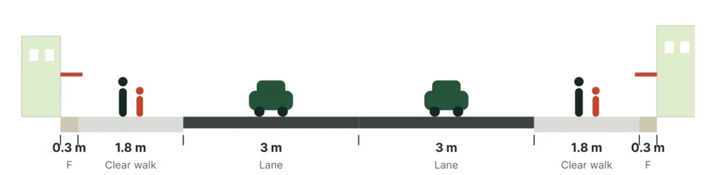
No parking and no tree strip; shade comes from awnings or trees in occasional wider spots. The 1.8 m path is an exception for quieter streets. A crowded street this narrow needs a change in traffic circulation.
C · One-way street with a loading bay · 11.1 m

One traffic direction is traded for walking space and a 2.2 m bay for loading or short parking. A full-size bus does not fit in a bay this narrow: here buses stop in the traffic lane at a raised boarding kerb, or the section is widened locally for a designed bus bay. Check the effect on nearby streets, bus routes, emergency access and junction queues first.
D · Wide town road, parked on both sides today · 21.9 m

Many larger towns have a four-lane road whose outer lanes are already lost to parked vehicles. Make that official and orderly: two through lanes, marked parking bays that stop short of every crossing and bus stop, and a centre lane for right turns and pedestrian refuges. The space won back becomes sidewalk.
Proposal. Concept allocations, subject to survey. Lane widths and every bus stop layout must pass bus and lorry swept-path checks, including the 12 m low-floor Metro Bus now running in Colombo and planned for Kandy, Galle and Jaffna.S16 S15
Where none of these fit: consider timed vehicle access, a pedestrian-priority market street, a frontage agreement, or a parallel accessible route with safe links. A shared surface is not a casual fix for a busy main road and is hard for blind people to read. Keep a protected, detectable walking zone wherever possible.
One tactile paving standard, applied the same way in every town
Tactile tiles are read with a cane and through the soles of the feet. Each pattern has one meaning, and the meaning depends on the pattern, the direction it is laid and where it is used. Colour helps people with low vision, but the texture carries the message.

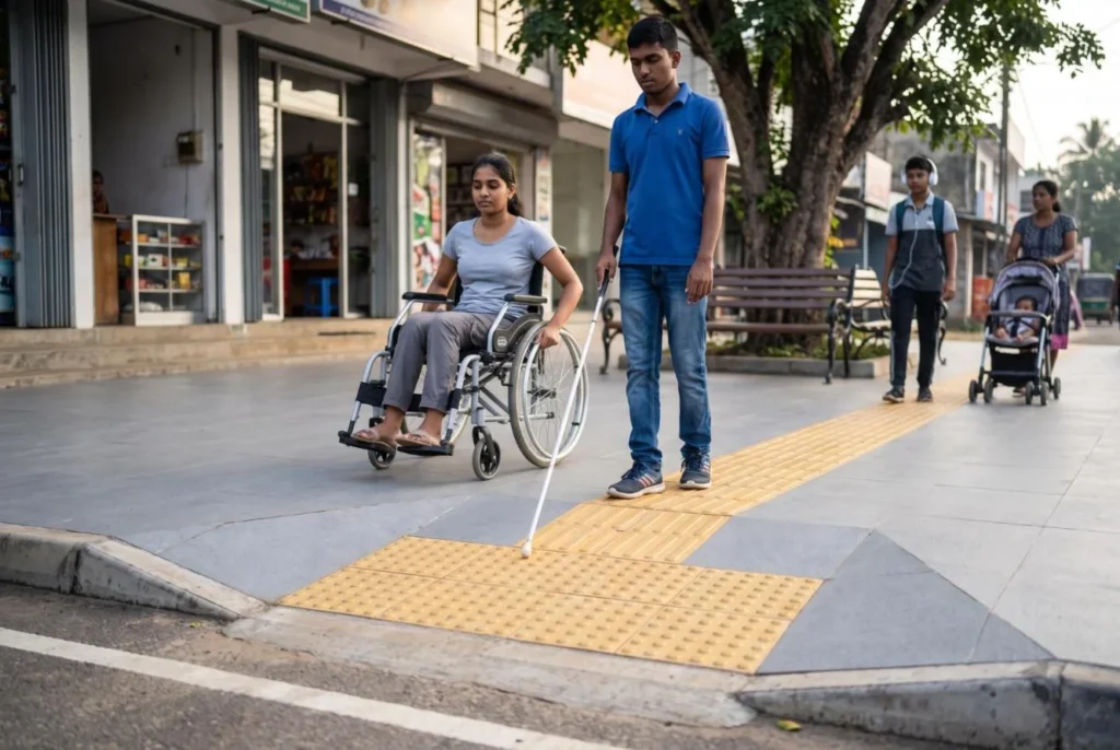
| Feature | Do this | Avoid this |
|---|---|---|
| Warning surface | The approved dot pattern at crossings and defined hazards | Decorative dots with no fixed meaning |
| Guidance surface | The approved guidance pattern, laid along the route, only where a route crosses open space | A strip that leads into a pole, a drain or a parked car |
| Contrast | A durable contrast with the surrounding paving | Assuming yellow always stands out |
| Crossings | Tactile layout lined up with the crossing itself | A ramp that points diagonally into a junction |
| Signals | Sound or touch confirmation and enough crossing time | Visual-only signals on key accessible routes |
| Shop entrances | A stable, step-free threshold inside the frontage strip | Private ramps sitting in the public path |
One national detail sheet
Commission a single set of details for signal crossings, zebra crossings, side streets, bus stops and plazas. Confirm the Sri Lankan rules first, adapt recognised guidance to fill the gaps, and settle it with blind and low-vision organisations. Do not mix the conventions of several countries in one street.
Test before making thousands of tiles
Build one full-size crossing and 20 m of sidewalk. Test it wet and dry with wheelchair users, cane users, people with walking frames and people with low vision. Check detectability, slipping, wheelchair vibration, drainage, glare and orientation. Reject any guidance line that ends at an obstacle or points the wrong way.
More than tiles. Include level resting areas, seats with backs and arms, readable wayfinding in the local languages, accessible bus boarding space and room for a wheelchair to turn. A QR code or phone app can add to these. It cannot replace them.
Singapore lens
At over 1,000 Singapore crossings, an older person or a person with a disability taps a concession card on the signal pole and gets 3 to 13 more seconds of green man.S52 Sri Lanka does not need the card reader to copy the principle: set crossing times for the slowest users near hospitals, markets and temples.
At 30 km/h a town centre forgives mistakes

Proposal. Adopt a 30 km/h operating environment in busy commercial cores and around schools, with a lawful designation and street geometry that enforces it. The World Health Organization backs low speeds wherever people and vehicles mix.S32 A sign on a pole, with no change to the street, is not a treatment.

| Situation | Treatment to assess |
|---|---|
| Slow two-lane shopping street | Raised crossing with clear visibility and accessible approaches |
| Busy multi-lane road | Signals, a central refuge and a lane-by-lane conflict check; paint alone is not enough |
| Side street meeting the main street | Continuous sidewalk across the mouth, or a raised entry, with a tight corner radius |
| School or hospital | A crossing on the route people really take, lighting, and supervision if needed |
| Fast approach to a town | Slow traffic before the first pedestrian conflict: gateway plus enforcement |
| Expressway | No crossing at road level; local links over or under |
As a survey starting point, look for a crossing opportunity every 80 to 150 m in the busiest core, then place each one by demand, junctions, bus stops and visibility. It is a starting point for survey, not a national spacing rule.
Crossing 6.5 m at 1.0 m a second takes 6.5 seconds of walking; crossing 12 m takes 12. Signal timing also needs start-up and clearance time and an allowance for slower users. The sums show why a shorter crossing matters. They do not set a legal signal timing.
Footbridges and subways add detours, stairs and lift maintenance. They are not the default on a shopping street. Consider them only where the traffic function and the site truly need separation and an accessible, convenient route can be kept working. Never fence off the line people walk without giving them a real alternative.
Singapore lens
Singapore’s Silver Zones, started in 2014, combine a 30 or 40 km/h limit, narrower lanes, raised and two-stage crossings and longer green man time in areas with many older residents. In the first 15 zones, accidents fell from 14 to 4 a year on average. Across all zones the rate is down about 80%.S46 S45 S51
Where two roads meet, give every movement its own place
Most Sri Lankan town junctions are a plain cross. One vehicle waiting to turn right blocks everyone behind it, and people cross the full width of the road. Singapore junctions separate these movements. Three of its ideas fit Sri Lankan towns; one needs care.
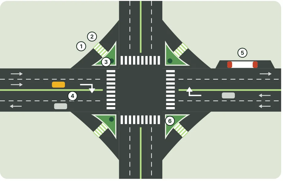
- Left-turn lane. Left-turning vehicles leave the main lanes before the signal and do not queue at it.
- Raised crossing on the turn lane. One lane wide, level with the sidewalk. Every turning driver slows to walking pace.
- Island. A protected place to wait. People cross the short lane first, then wait for the signal to cross the main road.
- Right-turn pocket. A turning vehicle waits in its own lane, with its own signal arrow where there are signals.
- Bus bay after the junction. The bus stops clear of the crossing and the turning lanes, beside a raised kerb.
- Shorter main crossing. The islands cut the distance and the time a person spends in the road.
The care needed with left-turn lanes
A lane that lets vehicles turn without stopping also lets them turn without looking. The driver watches for a gap in traffic from the right while a person steps off the kerb on the left. For that reason a free-flowing left-turn lane belongs only at large junctions on main roads, and only with all three protections: a tight angle that forces a slow turn, a raised zebra crossing, and an island big enough to stand on with a pushchair or wheelchair.
In a crowded shopping core, do the opposite. Keep the corner tight, with no turn lane, so vehicles turn slowly and the crossing is short.
Singapore lens
Singapore now controls right turns with red, amber and green arrows at over 1,200 junctions, and reports about 40% fewer accidents at them.S47 A turning pocket is a cheaper step in the same direction and needs no signal.
Where each idea belongs
| Idea | Use it | Avoid it |
|---|---|---|
| Left-turn lane with island | Wide junctions on A and B roads at the edge of the core | Narrow streets; places with heavy foot traffic |
| Right-turn pocket | Any junction where one waiting vehicle blocks the road | Where the width must come out of the sidewalk |
| Raised crossing | Shopping streets, schools, markets, turn lanes | Fast multi-lane approaches without signals |
| Bus bay | After the junction, where width allows | Where it would narrow the clear path |
The small-town version: a right-turn pocket on a two-lane road

The goal is access to the town, not a parking space outside every shop
| Street use | Operating proposal |
|---|---|
| Customer parking | Count what exists; use signed pockets with time limits; test paid parking where the law allows |
| Accessible parking | Signed spaces joined to a step-free route, close to essential services |
| Deliveries | Agreed loading hours and bays, with exceptions for essential and perishable goods |
| Three-wheelers | Marked ranks with a queue limit, clear sightlines and safe boarding |
| Motorcycles | Compact marked parking off the sidewalk; no riding on the walking route |
| Buses | A boarding platform, a shelter outside the clear path, and a crossing close by |
| Cyclists | Protected space on faster roads where it fits; mixed with slow traffic only after assessment |

Bus stops built for the new buses
A pilot of low-floor Metro Buses with wheelchair ramps began on two Colombo routes in April 2026, and the 2027 Budget plans services for Kandy, Galle and Jaffna.S16 S17 S15 A low floor is wasted if the bus stops a metre from a broken kerb. Every stop on a programme corridor should have a raised, level boarding edge the bus can pull up against.
All three of those cities are pilot candidates in Part 4. Design the stops and the sidewalks as one job with the bus operator.
Protect trade during the change
Count parking use and turnover before assuming a shortage. Give traders a signed map of parking and delivery access. Use existing public and private lots first, and make the walk from each lot safe in rain and after dark. Where surveys show real demand, a parking building delivered with a private partner can replace the spaces removed from the street; Part 5 sets out how.
Bus stops must match the street. A stop in the traffic lane can cut the conflict of buses pulling back out on a slow town street; a bay may suit another road. Assess bus dwell time, queues, junction spacing and passenger numbers. Neither layout may leave waiting passengers or a wheelchair user standing in the clear path. Agree each stop with the Sri Lanka Transport Board, private operators and the transport authority. The walking route must never become overflow parking.
Do not paint a lane for every vehicle type because traffic is mixed. Most small towns have no room. Separate people on foot first, cut dangerous speed differences, manage stopping and turning, and add protected cycling where the corridor can hold it.
Drainage first, then paving, shade and lighting
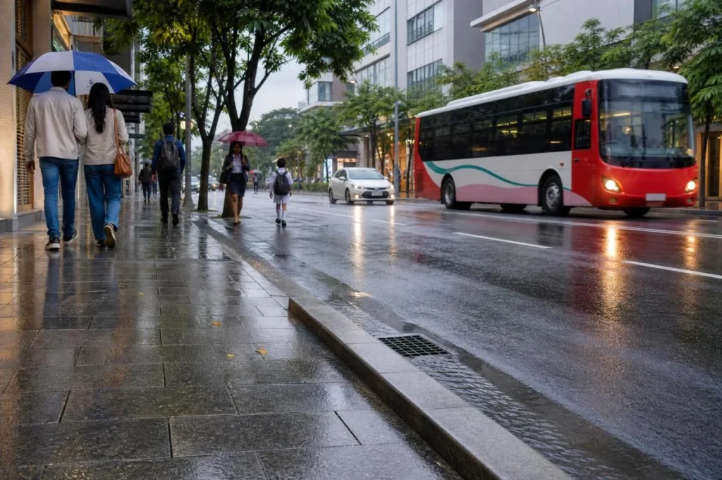
Survey outfall levels, drain condition, flood history and utility crossings before fixing any sidewalk level. A new raised pavement must not push floodwater into shops. Close the drain under the sidewalk with designed, firmly seated, non-slip solid covers, with hinged or lift-out covers at intervals for cleaning. Water enters through small inlets at the road edge, not through grilles in the walking path; the next page shows how. A sealed drain with no access is a failure waiting for the next monsoon.
| Element | Specification approach |
|---|---|
| Walking surface | Firm, stable and slip-resistant when wet; no polished tile or uneven decorative stone |
| Block paving | Quality-controlled units on an engineered base with edge restraint |
| Concrete option | Broom-finished panels with controlled joints; plan for curing time and utility access |
| Trees | Shade species suited to the local climate, with enough soil and managed roots |
| Tree position | Outside the clear path and sight triangles; clear trunk height specified |
| Rain gardens | Only after checks on infiltration, groundwater and upkeep; always with a safe overflow |
| Lighting | Designed so faces and crossings are evenly lit; fittings that can be reached and repaired |
| Furniture | Repairable benches, bins and bollards, only where clear width remains |
Verified fact. Sri Lankan accessibility regulations require stable, firm, slip-resistant surfaces on accessible routes.S31 Material acceptance must include wet-condition testing, dimensional tolerances and a trial panel, not appearance alone.
Plant fewer trees, and plant them well
The cost model allows about 80 trees per corridor kilometre. That is a budget quantity, not a spacing rule. Narrow streets may need shade from coordinated awnings instead. Do not plant large-canopy trees in undersized pits or under power lines. Require watering, replacement of failures, and at least 90% survival after two years. Use grid LED lighting by default and solar only where whole-life battery cost supports it.
Singapore lens
Singapore treats rain and sun as transport problems. A January 2018 parliamentary reply said government had spent about S$330 million on close to 160 km of covered linkways over the previous five years, across the Walk2Ride programme, public housing estates and community schemes: about S$210,000 per 100 m at the prices of that time.S53 An April 2025 reply plans 50 km more.S54 That is far beyond this budget, and it is the wrong first step for Sri Lanka. Trees and coordinated awnings give most of the benefit at a fraction of the cost.
Water enters at the road edge, runs under the sidewalk, and passes a litter trap
An open or grilled drain along a sidewalk is a hazard to walk beside and a bin for everything that blows past. The programme standard is a closed system: the sidewalk surface is solid, the water enters at the road edge, and litter is caught at one place built for the purpose.
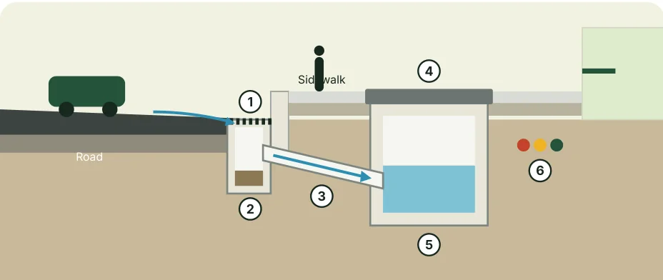
- Road inlet. A small grating in the gutter line beside the kerb, set just below road level. The only grille in the street, and it is not on the walking path.
- Silt pit. A sump under the inlet holds sand and stones so they do not enter the main drain.
- Connecting pipe. Carries the water under the kerb into the main drain.
- Solid cover. The main drain is closed with flush, load-rated, non-slip covers. Hinged or lift-out covers at set intervals give access for inspection and cleaning.
- Main drain under the sidewalk. A covered concrete channel sized by a drainage engineer for the local rainfall.
- Utility ducts. In their own trench, separate from the drain.
The litter trap: one chamber downstream, cleaned on a schedule
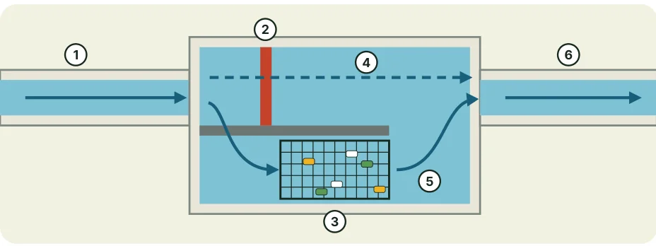
- Covered drain arrives from the corridor, carrying water and whatever got in.
- Low weir. In ordinary rain all the water is turned into the trap bay.
- Net or basket. A removable mesh catches bottles, wrappers and leaves. Water passes through. The trap removes litter; it does not treat the water.
- Storm bypass. In a heavy storm, or if the net is full, water rises over the weir and runs straight on, so a full net does not close the drain. Bypass flow can carry litter with it.
- Sump. Sand settles here below the outlet level.
- Outflow continues to the canal, stream or main drain.
What the bypass is for
The net screens the ordinary flow, which carries much of the litter. The bypass is there to keep drainage capacity when the basket is full or the flow is greater than the trap can pass. It lowers the risk that a litter trap causes flooding. It does not remove flood risk: the inlets, the main drain and the bypass must be checked by a drainage engineer for the design storm and for water levels downstream, and the trap needs a funded cleaning crew.
Place the chamber at the downstream end of each corridor, off the walking path, where a small lorry can reach it to lift the basket or vacuum the sump.
| Task | How often |
|---|---|
| Road inlets and silt pits | Checked monthly; cleared before each monsoon and after major storms |
| Main drain | Inspected through the access covers twice a year; desilted when needed |
| Litter trap | Inspected weekly in the first season, then emptied weekly to monthly by measured fill |
| Records | Weight or volume removed at each visit, so the schedule follows the evidence |
Singapore streets follow the same pattern: small inlets at the road edge, a covered drain beneath the footpath, and hinged covers that open for inspection. Where land allows, planted swales and underground detention tanks can also slow and store storm water; both need soil, groundwater and maintenance checks, and neither replaces a working covered drain.
Shared utility ducts and a litter system for every corridor
Two more things undo a new sidewalk within a few years: a utility company digging it up, and nowhere to put a wrapper. Both are cheap to design in while the trench is open and expensive to fix afterwards.
Cables: build the ducts now
Proposal. Lay shared utility ducts and draw chambers under every new sidewalk, with spare ducts for future use and road crossings at each junction. The standard kilometre already carries Rs 10 million for minor utility work and ducts. Once ducts exist, telecom and low-voltage lines can move underground street by street without breaking the paving again.
Overhead cables that stay for now should be bundled, re-fixed to fewer poles, and kept clear of awnings and trees. Poles move out of the clear path into the furniture strip.
Putting all electricity underground is a different scale of work: new cable, transformers, switchgear and a new connection to every shop. It is priced as a separate option in Part 5, to be tested in pilot cores first.

Bins: the cheapest drain protection there is
| Item | Design rule | Upkeep rule |
|---|---|---|
| Street bins | At bus stops, crossings, food shops and market entrances; in the furniture strip; lidded against rain, crows and dogs | Emptied daily in busy cores; an overflowing bin is logged as a defect |
| Spacing | As a starting allowance, about every 50 m in the commercial core and at every bus stop, then adjusted by observed litter | Reviewed after the first three months |
| Sorting | Paired bins only where the local authority already collects recyclables separately | No sorted bins without sorted collection |
| Traders | Every food and market trader has a named bin or collection time | Written into the frontage and vending agreement |
| Collection point | A screened hard-standing bay for bagged street waste and drain waste, outside the walking path | Waste removed the same day |
Bins are inside the Rs 6 million street furniture line of the standard kilometre. Road inlets, covers and the litter trap are inside the Rs 32 million drain line.
Singapore lens
Singapore keeps litter out of its drains with daily street cleaning and littering fines that are actually enforced. The hardware is the smallest part. Sri Lankan towns should copy the routine before the equipment.
Tidy the street without erasing the town
A town can look cared for without every building matching. Keep the small-shop pattern, the three languages on the boards, the colours and the trading character. Fix what actually harms the street: clashing sign sizes, hanging cables, unsafe awnings, broken plaster and entrances that spill into the path.

| Layer | Proposed frontage code |
|---|---|
| Signboards | One shared mounting band and maximum projection per block; every shop keeps its own name and logo |
| Awnings | One clear height, safe supports, and rainwater taken back to a managed drain |
| Facades | Repair plaster, gutters and anything dangerous; a restrained palette agreed block by block |
| Cables and equipment | Combine cable routes; screen equipment where ventilation and access allow |
| Ground level | The public path stays level; each shop’s step is solved inside an agreed entrance detail |
| Goods and vending | Marked trading space outside the protected path, with room to browse and queue |
A grant that asks owners to share the cost
Planning assumption. A public contribution of up to Rs 100,000 per eligible frontage, with the owner normally paying at least half the eligible cost. The cost model includes 100 contributions per kilometre, or Rs 10 million. This is a planning allowance, not a surveyed shop count.
Higher help only through an open, means-tested scheme for vulnerable small traders. Structural rebuilding, asbestos handling, major rewiring and upper-floor redevelopment need separate assessment and funding. No facade grant for a landlord renovation that pushes out the trader who was there.
Singapore lens · 1822
In 1822 Singapore’s first town plan required every house to give up a strip at its front as a “continued and covered passage on each side of the street”.S57 That became the five-foot way. Two centuries later the rule survives in modern form: new buildings facing a road must still provide a public covered walkway.S55 The lesson is not the arcade. It is that the walking strip was written into the building rules, so it did not depend on goodwill.
Fair implementation. Record ownership, tenancy, heritage status and permissions. Agree temporary shop access and signs during works. Offer design help and sample details before enforcement. Give street vendors practical trading alternatives; moving them out is not beautification. No political portraits on public street assets, and no sponsor branding outside the regulated advertising frames described in Part 5.
What a street built in 2027 can do that one built in 1997 could not
The core of this programme is old technology done properly: level paving, closed drains, shade. But several newer methods are now cheap and proven enough to design in from the start. They are sorted here by how ready they are for a Sri Lankan town.
| Method | What it does | Readiness |
|---|---|---|
| Countdown and audible signals | Shows people how many seconds remain and gives a sound for those who cannot see the light. Crossing times set for the slowest users. | Ready now |
| LED street lighting with remote monitoring | Uses far less power than older lamps and reports its own faults, so a dark crossing is fixed in days, not months. | Ready now |
| Speed-activated signs and camera enforcement | A sign lights up for a speeding driver; cameras enforce the limit without a police officer at every town gate. Fits the driver demerit point system funded in the 2027 Budget. | Ready now, with the legal process |
| Raised junctions and continuous sidewalks | The whole junction, or the mouth of a side street, is lifted to sidewalk level. Drivers cross the walking path, not the other way round. | Ready now |
| Precast modular drains, kerbs and ducts | Factory-made units laid quickly in short work fronts, with consistent quality and less time with the street dug up. | Ready now |
| Phone and QR code defect reporting | A code on each lamp post and bin links to a report form with the location filled in. Always paired with a phone number. | Ready now |
| Digital asset register | Every drain cover, light, tree and crossing mapped with its owner and condition, so upkeep is planned and not discovered. | Ready now |
| Pay-by-phone parking | Timed, paid street parking without meters or attendants handling cash. Income goes to the corridor maintenance fund. | Pilot first |
| Permeable paving and tree-pit rain gardens | Lets rain soak into the ground near trees and parking bays, easing the load on drains and cooling the street. | Pilot first: needs soil and groundwater checks |
| Drain water-level sensors | A low-cost sensor in the main drain and at the litter trap warns when water is rising or the trap is full. | Pilot first |
| Real-time bus arrival displays | Shows the next bus at the stop. Needs the bus fleet to carry tracking, as the Metro Bus fleet does. | Pilot first, with the operator |
| Light-coloured and recycled-content surfacing | Paler paving stays cooler underfoot. Recycled plastic or rubber in asphalt is being trialled in several countries. | Later: test durability locally before any wide use |
| Solar lighting | Useful where no grid supply exists. Batteries are the weak point and the main lifetime cost. | Only where the grid cannot reach |
A rule for choosing
Adopt a new method only if a local authority can keep it working with its own staff and budget in year five. A sensor nobody reads and a display that shows nothing are worse than not having them. Every item marked “pilot first” should be tested in two or three of the ten pilot towns and judged on cost, faults and use before it enters the national standard.
Singapore lens
Singapore uses most of this list every day: countdown timers and Green Man+ at crossings, a single app for reporting municipal defects, phone payment for street parking, and sensors in its drains. None of it replaced the basics. It was added to streets that already had sidewalks, closed drains and maintenance crews.
Part 3: Proof it can be done
Colombo has already built integrated streets. Singapore has measured what works for fifty years. Neither is a template. Both are evidence.
Sri Lanka has local examples to build on. The next step is wider, more consistent coverage.
The Metro Colombo Urban Development Project combined sidewalks with drainage, lighting, parking and street furniture. The Colombo Municipal Council describes upgrades to uneven or missing sidewalks along 11 km of road, lighting on ten streets, signals on three roads and drainage works.S34 That is the stated scope, not a measured outcome.
The World Bank completion report shows the built result in photographs.S35 It supports the claim that such works have been delivered in Sri Lanka. It does not show a crash reduction or a rise in shop sales, and this proposal does not claim one.
It was never only a Colombo idea
The Strategic Cities Development Project records work in Kandy, Galle and Jaffna, with support for Anuradhapura.S38 A 2018 Cabinet decision named 13 strategic cities: Kandy, Galle, Jaffna, Anuradhapura, Polonnaruwa, Trincomalee, Batticaloa, Badulla, Ratnapura, Matara, Kurunegala, Nuwara Eliya and Dambulla.S36 All 13 are in the proposed list of 60.
| Lesson to carry over | What to check before scaling |
|---|---|
| Package the whole street | Were drainage, utilities, crossings and walking space designed as one job? |
| Protect continuity | Do finished sidewalks carry on across side roads and private driveways? |
| Plan the upkeep | Who cleans the drains, replaces tiles and keeps parked vehicles off? |
| Use local capacity | Which materials and contractors held up over several monsoons? |
| Measure outcomes | Did access, footfall, safety and trader experience improve? |
Before fixing the national specification, commission a short condition audit of selected Colombo and strategic-city streets. Record defects, repair costs and what users say. Copy the details that survived real use. Do not copy decorative finishes whose upkeep has never been proven.
The programme should align with the Road Safety Action Plan 2025 to 2026, approved by Cabinet on 3 November 2025, and with its successor.S37 S03 A rate denominator on the Cabinet webpage appears inconsistent and is not used here.
Singapore, part one: a city that wrote the sidewalk into its rules
Singapore is a rich, compact city-state and Sri Lanka is neither. But both are hot, wet and crowded at street level, both inherited colonial shophouse streets, and both are ageing. Singapore is useful because it publishes what it builds and what happened next.

1. The five-foot way, 1822
The first town plan made every house provide a covered public passage along its front.S57 Shade, shelter and a continuous path came from one line in a building rule.
2. Two widths, always
Planning guidance states an overall width and a clear width for every covered walkway, graded by distance from a station: 3.0 m clear nearest, then 2.4 m, then 2.0 m.S55
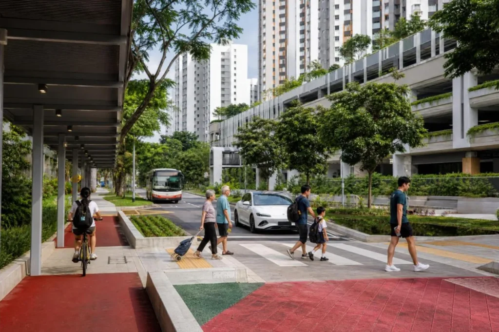
3. An accessibility code that keeps moving
The Code on Accessibility was revised again in 2025 and applies to plans submitted from 1 November 2025. Accessible routes are 1.5 m or 1.8 m wide by building type.S56 The point for Sri Lanka: the 2006 regulations need the same regular review.
4. Shelter as transport policy
Covered linkways join stations and bus interchanges to homes, schools and clinics within 400 m, and now extend to Friendly Streets within 800 m of a station.S54
None of these four needed new technology. Each one is a rule about who the edge of the street belongs to.
Singapore, part two: slower streets, and the numbers that followed
80%
lower accident rate for senior pedestrians inside Silver Zones
40%
fewer accidents at junctions given signalised right turns
9 in 10
residents say walking improved on Friendly Streets
1,000
small local safety fixes delivered every year
5. Silver Zones
Since 2014, areas with many older residents get a 30 or 40 km/h limit, narrowed lanes, raised crossings, two-stage crossings and more green man time. There were 40 zones by 2023.S47 S45
6. Friendly Streets
Launched in 2023 with five pilots near markets, schools and stations. Ten more were due in 2026 and fifteen more are in design, with every town to have one by 2030. Locations and features are settled with residents before work starts.S49 S48
7. School Zones, all day
From 1 January 2026 the 40 km/h limit near primary schools applies around the clock, weekends included, to remove any doubt about when it is in force.S50
8. Fix the junction, not the driver
Discretionary right turns have been replaced with red-amber-green arrows at over 1,200 junctions. Those junctions recorded about 40% fewer accidents.S47
9. Small fixes, every year
The Land Transport Authority uses police crash reports and resident feedback to deliver about 1,000 local improvements a year: humps, markings, sightline fixes.S47 This is the closest match to Sri Lanka’s 712 identified locations and the Rs 60 million per district now set aside.S12 S13
How Singapore rolls a programme out
Pilot five. Publish the result. Do ten. Then commit to every town by a date. The ten-pilot gate in Part 4 follows the same pattern on purpose.
Evidence from abroad. Singapore results describe Singapore streets. They show that the treatments work when built and maintained properly. They are not forecasts for Sri Lankan corridors.
Singapore, part three: what to copy, what to leave, and one warning
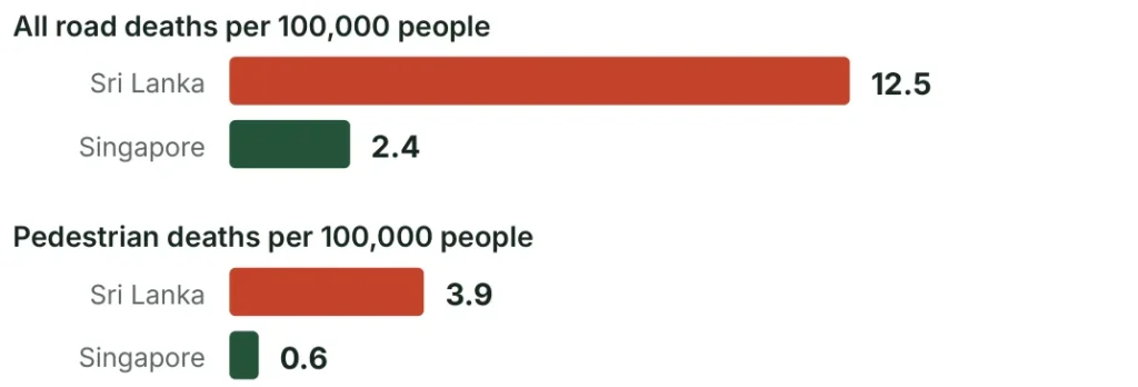
A person in Sri Lanka is about 5 times more likely to die on the road than a person in Singapore, and about 6.7 times more likely to die as a pedestrian.
The gap reflects income, vehicle mix, enforcement and emergency care as well as street design. It shows what is possible, not what sidewalks alone will deliver.
| Copy | Adapt | Leave |
|---|---|---|
| State a clear width, not just an overall width | Covered walkways: use trees and awnings first | Card-activated signals as a first step |
| Pilot, publish, then scale | Silver Zones: start around hospitals, markets and places of worship | Islandwide covered linkways at S$2 million a kilometre |
| Lower limits backed by street geometry | Friendly Streets: fit them to main roads that double as shopping streets | Grade-separated crossings as a default |
| Choose sites with residents | School Zones: add supervised crossings at opening and closing time | |
| Fund a yearly stream of small fixes |
The warning
Singapore had its worst year in a decade in 2025: 149 deaths. Elderly pedestrian deaths rose from 11 to 27, three quarters of all pedestrians killed. Fifteen fatal jaywalking cases involved older pedestrians, up from seven in 2024. Speeding violations rose to 253,550.S42 S43
Two lessons follow. First, good infrastructure does not finish the job; enforcement and upkeep never stop. Second, older people cross where the walk is shortest, not where the crossing was drawn. Put crossings on the line people already take, or the best-built sidewalk will still lead them into the road.
Sri Lanka is ageing too. The street built now is the one today’s workers will grow old on.
Part 4: The programme
Sixty towns, every district, four waves. Ten pilots go first, and nothing scales until they have been through a monsoon.
Choose towns by evidence, publish the scores
The list of 60 gives the programme a concrete national starting point. It includes the 13 strategic cities and at least one town in every district. It is not a claim to hold the 60 highest-risk places. Keep a reserve list and swap towns in when measured need, readiness or value for money justifies it.
| Selection criterion | Weight | Evidence required |
|---|---|---|
| Fatal and serious injury risk | 35% | Three years of geocoded crashes plus a proactive risk audit |
| Pedestrian demand and essential access | 25% | Counts; links to schools, hospitals, markets and transit |
| Missing or inaccessible walking network | 15% | Measured clear widths, continuity, crossings and obstructions |
| Deprivation and regional inclusion | 10% | Local access needs and service catchments |
| Readiness and maintenance | 10% | Right of way, utilities, authority agreement, funded upkeep |
| Local economic benefit | 5% | Trader survey, market role and footfall baseline |
Use a published scoring scale and show the evidence behind every score. Do not score by town size. Missing crash reports should trigger a safety audit, not a low score. The police list of 712 accident-prone locations is a ready first input.S12 No points for political sponsorship.
What the three budget classes mean
| Class | Towns | Allowance per town | Direct works per town |
|---|---|---|---|
| A Major or complex centre | 12 | 5 corridor km at Rs 200 m/km | Rs 1,000 m |
| B Regional or secondary hub | 24 | 3 corridor km at Rs 150 m/km | Rs 450 m |
| C Focused town core | 24 | 2 corridor km at Rs 100 m/km | Rs 200 m |
Planning assumption. The classes are scope and complexity allowances, not population ranks. Class A is not first in line. A lower-cost class assumes fewer major drain and utility works, never thinner construction or narrower paths. Pilot kilometres are inside these lengths, not added to them.
Every district, from Point Pedro to Matara
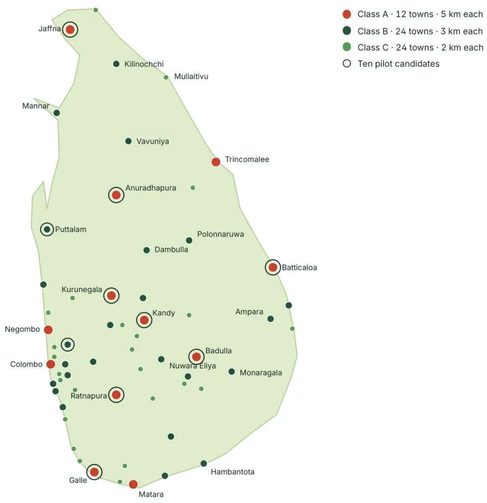
60
towns
25
districts
180
corridor km
| Completion wave | Towns |
|---|---|
| Wave 1 · 2028 | 10 |
| Wave 2 · 2029 | 15 |
| Wave 3 · 2030 | 17 |
| Wave 4 · 2031 | 18 |
This is a planning shortlist, not a crash ranking. Order can change after the first national screening.
Candidate towns and their first corridor
Town register, 1 to 30
| No | Town | District | Class | Done by | First corridor focus |
|---|---|---|---|---|---|
| 01 | Colombo | Colombo | A | 2031 | Repair gaps and interchange links |
| 02 | Kandy (pilot) | Kandy | A | 2028 | Transit and constrained commercial core |
| 03 | Galle (pilot) | Galle | A | 2028 | Bus, rail and trading connections |
| 04 | Matara | Matara | A | 2029 | Regional bus and shopping hub |
| 05 | Jaffna (pilot) | Jaffna | A | 2028 | Market and transit connections |
| 06 | Kurunegala (pilot) | Kurunegala | A | 2028 | Busy junction and regional interchange |
| 07 | Anuradhapura (pilot) | Anuradhapura | A | 2028 | Market, transit and civic access |
| 08 | Ratnapura (pilot) | Ratnapura | A | 2028 | Drainage and commercial core |
| 09 | Badulla (pilot) | Badulla | A | 2028 | Hill town school and transit access |
| 10 | Batticaloa (pilot) | Batticaloa | A | 2028 | Commercial and essential services |
| 11 | Trincomalee | Trincomalee | A | 2029 | Regional market and transit |
| 12 | Negombo | Gampaha | A | 2029 | Commercial and visitor access |
| 13 | Gampaha (pilot) | Gampaha | B | 2028 | Rail, bus and shopping connections |
| 14 | Kalutara | Kalutara | B | 2029 | Main road and transit connections |
| 15 | Panadura | Kalutara | B | 2029 | Rail, bus and busy trading streets |
| 16 | Moratuwa | Colombo | B | 2029 | Rail, commercial and industrial access |
| 17 | Kaduwela | Colombo | B | 2029 | Bus and junction conflicts |
| 18 | Nuwara Eliya | Nuwara Eliya | B | 2030 | Visitor and resident walking routes |
| 19 | Matale | Matale | B | 2029 | Market and through road conflicts |
| 20 | Dambulla | Matale | B | 2029 | Produce market and regional junction |
| 21 | Hambantota | Hambantota | B | 2031 | Connect civic and trading nodes |
| 22 | Tangalle | Hambantota | B | 2030 | Bus and coastal town centre |
| 23 | Vavuniya | Vavuniya | B | 2029 | Regional road and transit hub |
| 24 | Kilinochchi | Kilinochchi | B | 2029 | Linear main road and services |
| 25 | Mannar | Mannar | B | 2030 | Core market and public services |
| 26 | Ampara | Ampara | B | 2030 | Civic services and commercial access |
| 27 | Kalmunai | Ampara | B | 2030 | Dense commercial main street |
| 28 | Puttalam (pilot) | Puttalam | B | 2028 | Mixed traffic and market access |
| 29 | Chilaw | Puttalam | B | 2029 | Rail, bus and town shopping |
| 30 | Polonnaruwa | Polonnaruwa | B | 2030 | Kaduruwela and service connections |
Class A: 5 km, Rs 1,000 m. Class B: 3 km, Rs 450 m. Class C: 2 km, Rs 200 m. Direct works only.
Town register, 31 to 60
| No | Town | District | Class | Done by | First corridor focus |
|---|---|---|---|---|---|
| 31 | Kegalle | Kegalle | B | 2029 | Constrained main road frontage |
| 32 | Bandarawela | Badulla | B | 2030 | Hill town market and transit |
| 33 | Monaragala | Monaragala | B | 2030 | Regional service centre |
| 34 | Embilipitiya | Ratnapura | B | 2030 | Regional trade and bus access |
| 35 | Homagama | Colombo | B | 2031 | Suburban rail and commercial core |
| 36 | Avissawella | Colombo | B | 2030 | Regional interchange and trade |
| 37 | Maharagama | Colombo | C | 2031 | Target missing connections |
| 38 | Kesbewa | Colombo | C | 2031 | Town core and bus access |
| 39 | Wattala | Gampaha | C | 2031 | Target school and shopping links |
| 40 | Ja-Ela | Gampaha | C | 2031 | Rail and commercial access |
| 41 | Horana | Kalutara | C | 2030 | Bus, market and civic links |
| 42 | Beruwala | Kalutara | C | 2031 | Local trade and coastal access |
| 43 | Ambalangoda | Galle | C | 2030 | Rail, bus and trading core |
| 44 | Hikkaduwa | Galle | C | 2031 | Visitor and resident main road access |
| 45 | Weligama | Matara | C | 2030 | Market and coastal town links |
| 46 | Akuressa | Matara | C | 2031 | Regional junction and market |
| 47 | Hatton | Nuwara Eliya | C | 2029 | Rail, bus and estate service hub |
| 48 | Gampola | Kandy | C | 2030 | Market and transit links |
| 49 | Nawalapitiya | Kandy | C | 2031 | Rail and hillside town access |
| 50 | Mahiyanganaya | Badulla | C | 2031 | Bus, trade and pilgrimage access |
| 51 | Haputale | Badulla | C | 2031 | Constrained hill town core |
| 52 | Wellawaya | Monaragala | C | 2031 | Junction and bus connections |
| 53 | Balangoda | Ratnapura | C | 2031 | Commercial through road |
| 54 | Mawanella | Kegalle | C | 2031 | Market and main road frontage |
| 55 | Kuliyapitiya | Kurunegala | C | 2030 | Civic, education and market links |
| 56 | Wennappuwa | Puttalam | C | 2031 | Linear trading and service streets |
| 57 | Kantale | Trincomalee | C | 2030 | Bus, market and main road |
| 58 | Akkaraipattu | Ampara | C | 2030 | Commercial core and public services |
| 59 | Mullaitivu | Mullaitivu | C | 2029 | District service centre access |
| 60 | Point Pedro | Jaffna | C | 2031 | Northern coastal trading core |
No population figure, crash score or detailed price is implied by this table.
One kilometre in ten towns, before a rupee goes to the rest
Start in 2027 with ten 1 km corridors, chosen to test ten different street conditions across all nine provinces. Puttalam gives a second North Western case. All ten towns have the rest of their package provisionally scheduled for 2028. Final selection depends on land, data, utilities and delivery capacity.
| Pilot candidate | What it should test |
|---|---|
| Kurunegala | Bus and junction management in a regional commercial centre |
| Kandy | Tight width, heritage and very high pedestrian demand; Metro Bus stops |
| Galle | Linked bus, rail and shopping access; Metro Bus stops |
| Jaffna | Market trading, shopfront coordination and accessible crossings; Metro Bus stops |
| Anuradhapura | Service access and shade in a spread-out town |
| Ratnapura | Flood-resilient drainage and shop floor levels |
| Badulla | Slopes and accessible routes in a hill town |
| Batticaloa | Eastern town core, drainage and trading access |
| Gampaha | Rail interchange, commuter flows and shop deliveries |
| Puttalam | Mixed traffic, market activity and heat |
The release gate
Planning assumption. A first ceiling of Rs 3.1 billion. Each pilot kilometre is priced at the rate for its town class: eight Class A kilometres at Rs 200 million and two Class B kilometres at Rs 150 million, Rs 1.9 billion of direct works. Adding 8% programme support, 20% contingency and an 18% fiscal allowance gives Rs 2.870 billion. The remaining Rs 230 million pays for wider preparation. All of it sits inside the national envelope. Each pilot needs its own surveyed scope and estimate before tender; if a site costs more than its class rate, the length is reduced or the allocation is revised and reported. Trial undergrounding of power lines is outside this ceiling (see Part 5).
For scale, Rs 3.1 billion is about 14% of the Rs 22 billion the 2027 Budget gives to widening and improving selected roads.S14
What the pilots can and cannot show
Before scaling, review build quality, actual unit rates, disruption to traders, access performance and readiness to maintain. Three to six months will expose construction and operating defects, real unit costs and how much trade was disrupted. It cannot show a reliable fall in deaths. Safety evaluation must run for several years, against comparison corridors.
Test a machine-assisted paving package and a conventional small-contractor package side by side. Compare accepted finished work and total days of disruption, not blocks laid per hour.

Five years, four waves, one gate at every step
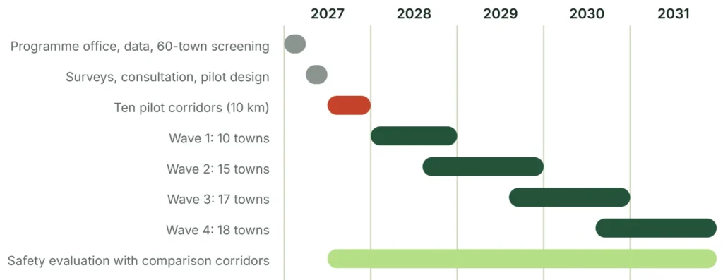
| Period | Main work | Condition for release |
|---|---|---|
| 2027, months 1 to 3 | Programme team; data requests; screen 60 towns; agree a provisional standard | Named road owner and local maintenance owner |
| 2027, months 4 to 6 | Surveys; consultation; pilot designs; mock-ups; procurement | Independent safety and access review; priced quantities |
| 2027, months 7 to 12 | Build ten pilot corridors in sections; design remaining towns | Safe temporary access; funded utility agreements |
| 2028 | Complete wave 1; evaluate pilots; start wave 2 | Pilot defects corrected; actual costs published |
| 2029 | Complete wave 2; start wave 3 | Audit of quality, capacity and affordability |
| 2030 | Complete wave 3; start wave 4 | Verified maintenance performance; refreshed cost plans |
| 2031 | Complete wave 4; close gaps; hand over assets | Defects closed; asset register; funded upkeep |
One kilometre, start to finish
Allow 2 to 4 months for survey and design, 2 to 4 for approvals and procurement, and 3 to 6 for construction where utilities and right of way are manageable. Major drain rebuilding, land or heritage consent can push this past a year. These are planning durations, not observed rates.
Short work fronts
Work in sections of about 50 to 100 m. Keep a safe walking route and every shop door open. Run excavation, drainage, utilities, base, paving and crossings as one sequence. Never open every frontage in a street at once. Plan around the local monsoon and leave float; do not pour concrete in the rain to meet an opening ceremony.
Capacity is the real limit. A five-year national programme is possible only through several regional packages running at once. The tight constraint will be design, utilities, approvals and supervision, not tile laying. Yearly spending in Part 5 covers design, advance works and equipment across more than one wave, so it does not equal the value of towns opened that year.
Use machines for the repetitive work, people for the skilled work
| Method | Best use | Check before adopting |
|---|---|---|
| Mechanical block laying | Long, repetitive areas with pre-arranged paver layers | Trial real access, layer fit and full crew output |
| Vacuum lifting and mini plant | Slabs, drain covers, repeated handling | Operator training, exclusion zone, servicing |
| Precast kerbs and drains | Repeatable details at predictable levels | Loading, joint leakage, lifting, factory quality |
| Digital survey and GIS | Geometry, utilities, quantities, handover | One coordinate system; verify on site |
| Utility detection | Fewer strikes and redesigns | Records, detection and trial pits together |
| Factory sample panels | Consistent tactile and surface quality | Wet slip, strength, size, contrast, user acceptance |
| Digital inspection records | Defects, photos, quantities, payments | Independent sign-off; public reporting |
Evidence from abroad. Probst publishes a customer estimate of up to 1,000 m² a day for one of its paving machines.S40 It is a manufacturer-hosted statement, not a verified Sri Lankan rate, and it ignores utilities, drainage, base preparation, edge cuts and shop access.
A realistic test
The standard kilometre has 6,000 m² of sidewalk. That is 20 paving days at 300 m² a day, or 60 days at 100 m². Neither is the full construction period. Measure total cost and disruption against a manual crew before buying more machines.
Lease equipment through regional framework contracts at first. Require local parts, servicing, operator training and a utilisation plan before buying specialised imported machines.
Mechanise the tasks that are repetitive and hard on the body. Keep local jobs in drains, foundations, detailing, inspection, planting and upkeep. Do not promise that automation will both maximise jobs and minimise labour hours. It cannot do both.
Part 5: The money
Rs 150 million buys one kilometre of working street: both sides, drains included. Everything else in this part is multiplication, shown in full.
Where Rs 150 million goes
The standard Class B example covers both sides of a 1 km street: 2,000 m of sidewalk edge and 6,000 m² of sidewalk, at an average gross width of 3.0 m per side. All figures are 2026 concept allowances, not contractor quotations.
Why 3.0 m, when the main street section is 4.0 m. No corridor uses one section from end to end. The 3.0 m is a planning average over the sections in Part 2: about 40% of the length at the full 4.0 m (sections A and D), 20% at 2.7 m (section C) and 40% at 2.1 m (section B), which gives 2.98 m. Survey will replace this mix town by town. The mix is a costing assumption, not an allocation of street types: the 1.8 m clear path stays an exception for quieter constrained streets, assessed with disabled users, and busy commercial streets must meet the 2.4 m target. If a corridor is built at 4.0 m throughout, paving and base rise by 2,000 m², or Rs 15 million per kilometre, 10% of direct works. That must be re-priced, not absorbed. Rates include contractor overhead and profit and exclude the programme additions on the next page.
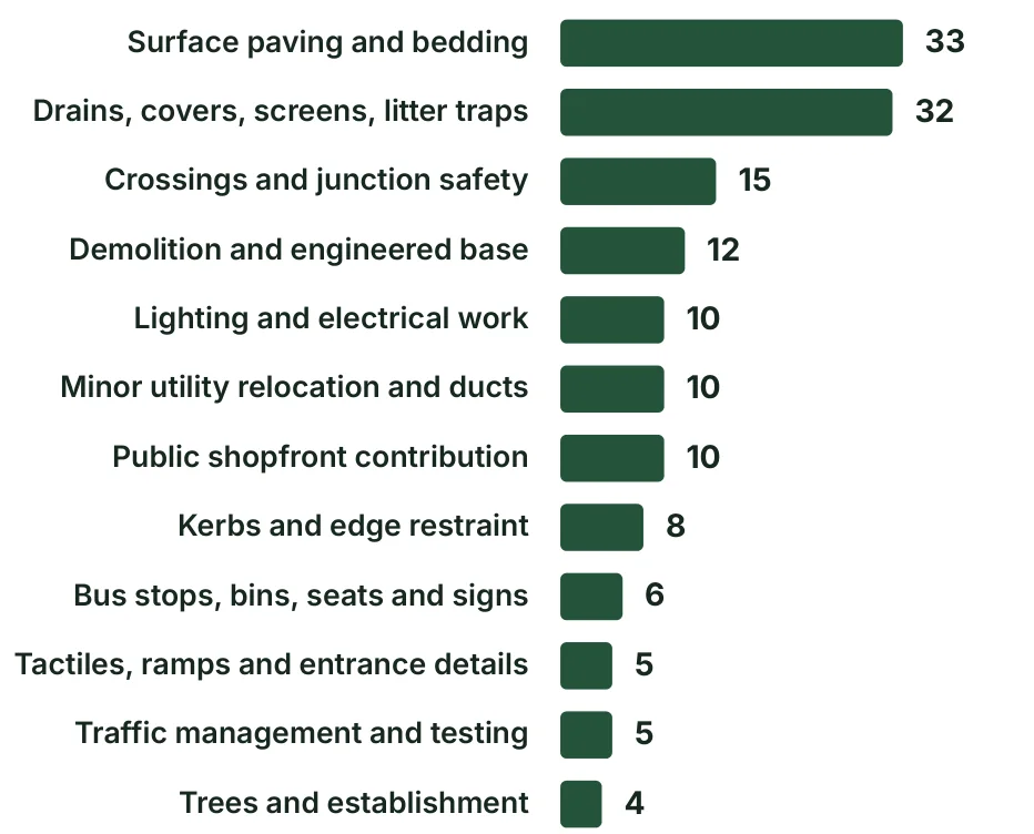
| Item | Quantity | Rate, Rs |
|---|---|---|
| Surface paving and bedding | 6,000 m² | 5,500 / m² |
| Drains, covers, screens, litter traps | 2,000 m | 16,000 / m |
| Crossings and junction safety | Allowance | Survey dependent |
| Demolition and engineered base | 6,000 m² | 2,000 / m² |
| Lighting and electrical work | 40 units | 250,000 / unit |
| Minor utility relocation and ducts | Allowance | Survey dependent |
| Public shopfront contribution | 100 fronts | 100,000 / front |
| Kerbs and edge restraint | 2,000 m | 4,000 / m |
| Bus stops, bins, seats and signs | Allowance | Survey dependent |
| Tactiles, ramps and entrance details | Allowance | Survey dependent |
| Traffic management and testing | Allowance | Survey dependent |
| Trees and establishment | 80 trees | 50,000 / tree |
Total direct works: Rs 150 million per corridor kilometre. Paving is 22% of it. Drains, base, crossings and utilities are the real job.
The drainage, utility and junction allowances must be replaced by measured bills of quantities. Sound existing assets can lower the cost. Structural drains or moving major power lines can raise it sharply.
Verified fact. The Western Province 2025 schedule of rates gives Rs 4,975 per m² for 60 mm natural rectangular paving and Rs 5,136 for coloured, including bedding and laying.S39 The model uses Rs 5,500 as a rounded later allowance. Base work is priced separately so a paving rate is not mistaken for a sidewalk cost.
Rs 41.7 billion, built up line by line

| Package | Calculation | Rs bn |
|---|---|---|
| Class A direct works | 12 towns x 5 km x Rs 200 m/km | 12.000 |
| Class B direct works | 24 towns x 3 km x Rs 150 m/km | 10.800 |
| Class C direct works | 24 towns x 2 km x Rs 100 m/km | 4.800 |
| Total direct works | 180 corridor km | 27.600 |
| Design, supervision, programme support | 8% of direct works | 2.208 |
| Physical contingency | 20% of direct works | 5.520 |
| Subtotal | Direct works plus the two additions | 35.328 |
| Fiscal and tax allowance | 18% of the subtotal, illustrative | 6.359 |
| Total at 2026 prices | Before future escalation | 41.687 |
Planning assumption. The 18% line is a cautious budgeting assumption, not a tax opinion. The final estimate must identify the taxes that apply, any exemptions and what can be recovered. The estimate stays in rupees; no exchange rate is used.
Included
Sidewalk works. Repair of ordinary local drainage. Selected crossings and junction treatments. Minor utility adjustments. Basic lighting and street furniture. Targeted frontage grants. Design, supervision, construction management and contingency.
Not included
Major land acquisition or resettlement. Demolition and rebuilding. Bypasses, bridges and subways. Trunk sewer or drain replacement. Full road resurfacing. Undergrounding of power lines. Multi-storey car parks. These need their own options and budgets; two of them are set out later in this part.
Calling this a paving programme would hide most of the work. Calling it the price of rebuilding every street in 60 towns would be just as wrong. It buys a first connected network of selected corridors.
What it costs each year, and how wrong the estimate could be

| Year | Share | 2026 prices | Escalated |
|---|---|---|---|
| 2027 | 10% | 4.169 | 4.377 |
| 2028 | 25% | 10.422 | 11.490 |
| 2029 | 30% | 12.506 | 14.477 |
| 2030 | 20% | 8.337 | 10.134 |
| 2031 | 15% | 6.253 | 7.981 |
| Total | 100% | 41.687 | 48.459 |
| Scenario | Five-year capital, Rs bn | Meaning |
|---|---|---|
| No escalation | 41.69 | Constant-price reference |
| 5% a year | 48.46 | Central planning scenario |
| 10% a year | 56.12 | Higher escalation test |
Uncertainty before surveys
Planning assumption. Use a screening range of about Rs 30 to 63 billion at 2026 prices: roughly 30% below to 50% above the central figure. This is a judgement, not a statistical interval. Major excluded works can take a town outside it. Do not add the range on top as more contingency.
In the context of the 2027 Budget
The 2027 Budget puts about Rs 487 billion into roads and railways.S14 This programme averages Rs 8.3 billion a year at 2026 prices, about 1.7% of that single-year figure. Its heaviest year, 2029, is under 3%.
Funding sequence
Seek a multi-year capital allocation with yearly release gates. Explore development-partner support for design, safety evaluation and accessible infrastructure; that is a possibility, not a commitment. Parking income and frontage contributions can help with upkeep but should not be counted on for capital until tested.
If the full sum is not available, build fewer complete, maintained corridors. Do not scatter the money across 60 ceremonial fragments that connect nothing.
What companies can pay for, and what they get back
Private money will not build drains. It can keep a street clean, lit and furnished for a decade if the deal is written properly. Treat companies as the answer to upkeep, not to the capital bill.
| Model | How it works | Use it for |
|---|---|---|
| Advertising concession | A company builds, cleans and repairs bus shelters, benches and bins at its own cost, in return for selling advertising in fixed panels for 8 to 15 years | The main route: bus stops and street furniture in every programme town |
| Adopt a street | A company funds upkeep of a named stretch for 3 to 5 years and gets a small standard plaque | Planting, cleaning and repairs on single corridors |
| Frontage obligation | Banks, supermarkets and fuel stations rebuild the sidewalk in front of their own premises to the national standard as a permit condition | Large frontages on programme corridors, at no cost to government |
| Business district levy | Shop owners in a centre pay a small levy into a jointly managed fund for cleaning, lighting and events | Larger towns, later, once traders have seen the result |
| Parking concession | A private operator runs paid street parking or a parking building and shares revenue | Towns with measured parking demand |
| Duct leasing | Government builds shared ducts and leases space to telecom companies | Income for upkeep; fewer road openings |
| Materials in kind | Cement, paving or lighting firms supply at cost in return for recognition | Small top-ups, always inside tender rules |
| Full PPP for sidewalks | A firm finances and builds the street and is repaid over years | Not recommended. Sidewalks earn nothing, so government pays anyway, plus financing cost |
Rules for advertising, so it does not become the next problem
- Fixed places only. Inside bus shelters and on approved freestanding panels. Never on the paving, trees, railings, crossings or signal poles.
- Outside the clear path. No panel may narrow the 2.4 m walking width or block the view at a crossing or junction.
- Capped. A set number of panels per shelter and per kilometre, at one standard size.
- No moving or digital screens near crossings and junctions.
- Content rules. No political advertising. No alcohol or tobacco. The three-language rule applies.
- Open tender by town cluster, with the contract and revenue published.
- Performance terms. Repair deadlines, penalties, and removal of everything at the end of the term.
- Ring-fenced income. Any revenue share goes to the corridor maintenance fund, not to general revenue.
Proposal. A three-year term suits upkeep sponsorship. It is too short for a company that must build shelters, which is why concessions of this kind usually run eight years or more. Confirm which body controls advertising rights on each road before tender. The draft Public-Private Partnership law, targeted for late 2026, would require a value-for-money and feasibility assessment before any partnership is approved; check its status at mobilisation.S20
Singapore lens
Singapore’s planning rules make developers provide the covered public walkway along their own frontage.S55 That is private money working inside a public rule, and it has held for two hundred years.
Parking buildings and underground cables, priced apart from the core programme
Both are worth doing in the right towns. Neither belongs inside the Rs 41.7 billion envelope, because either one could cost as much as the sidewalks. They are set out here as separate, optional packages with their own tests.
A. A parking building in each town, with a private partner
When parking comes off the main street, drivers need somewhere to go. In larger towns that can be a multi-storey building within a short walk of the shops.
Verified fact. The Urban Development Authority began a ten-storey building for 252 vehicles in Colombo Fort in 2020 at Rs 1.1 billion, about Rs 4.4 million a space, with shops on the ground floor.S18 In the same year Cabinet approved calling for private investors to build car parks with the Authority, including in Kandy and Anuradhapura.S19
Planning assumption. Take a simpler 200-space building at Rs 5 million a space in 2026 prices: about Rs 1 billion each. At Rs 100 an hour, six paid hours a day and 300 days a year, parking income is about Rs 36 million a year, or 3.6% of the cost before running expenses.
Parking fees alone will not attract an investor. A deal would need other sources of value: a lease of public land; ground-floor shops and upper-floor offices the investor can rent; removal of free street parking nearby, so the building has customers; and a 25 to 30 year build, operate and transfer term with capped tariffs and written service standards. Public land and development rights are not free even at a nominal rent. Value them, and count them as the public contribution in the value-for-money test. Whether investors will come is unknown until that assessment is done.
One for each of the 60 towns would be about Rs 60 billion, more than the whole street programme. Start with the 12 Class A towns, about Rs 12 billion of building cost before the value of public land, and only where a parking survey proves demand. Smaller towns should use surface lots.
B. All cables underground
Underground power and telecom lines clear the skyline, free the sidewalk of poles and survive storms. They are also the most expensive single item a street can carry.
Verified fact. The Ceylon Electricity Board 2025 rates put a new overhead low-voltage line at about Rs 4.1 million a kilometre and an 11 kV line at about Rs 7.5 million. No standard underground rate is published; such work is priced case by case.S21
Planning assumption. Underground distribution is widely taken to cost roughly five to ten times the overhead equivalent. On that rule of thumb, moving one low-voltage and one 11 kV route underground costs about Rs 58 to 116 million per corridor kilometre, before telecom lines and a new connection to every building. Across 180 km that is about Rs 10 to 21 billion. This is an illustration, to be replaced by an Electricity Board estimate.
Recommended path
- Build shared ducts under every programme sidewalk now. This is already in the core cost.
- As an optional trial, funded separately from the pilot ceiling and agreed first with the Electricity Board and the telecom operators, put all cables underground in the busiest 300 to 500 m of each pilot and record the real cost and disruption. On the rule of thumb above, ten trials cost roughly Rs 174 to 579 million before telecom lines, building connections, programme additions and tax.
- Extend town by town where heritage, tourism, storm damage or safety justifies it, funded with the Electricity Board and telecom operators, who gain lower fault and repair costs.
- Require every new building and major renovation on a programme corridor to take an underground connection.
The core programme stays at Rs 41.7 billion. These two options are decisions for later, town by town, with real surveys and real partners.
Fund maintenance from the start
Planning assumption. Reserve 2% of the Rs 27.6 billion direct works value for routine upkeep every year: Rs 552 million at full operation, in 2026 prices. It is separate from the capital envelope and should build up as corridors open.
| Routine task | Service requirement |
|---|---|
| Drains and inlets | Inspect before each monsoon and after major storms; clear blockages promptly |
| Surface defects | Make dangerous defects safe within 24 hours; full repair to an agreed priority |
| Crossings and lighting | Routine checks, fast hazard response, scheduled repainting |
| Trees | Water, prune for visibility and headroom, replace failures, manage roots |
| Encroachment | Regular clear-path inspections and fair, graduated enforcement |
| Cleaning | Daily in busy cores, matched to footfall and waste |
| Asset records | Every drain, light, tree and crossing logged with owner and condition |
Who pays, who answers
Before tender, name the authority for each asset and secure its budget. A road-owner agreement must say which agency repairs drains, lights and crossings, and which local body handles cleaning, planting, vending and parking. Utilities must reinstate any surface they open to the programme detail, with a warranty and an inspection.
Require a 24-month defects and tree-establishment period, with responsibility for latent defects and longer warranties where the contract allows. Do not accept handover on opening-day photographs. Inspect after heavy rain and after the first utility cut is reinstated.
Beyond routine
The 2% covers routine work, not renewal. Prepare a 20-year asset plan that schedules resurfacing, lighting replacement, drain repair and tree renewal separately, and publish the yearly liability when each town package is approved.
Singapore lens · A warning
In the 1880s Singapore tried to clear traders who had filled the five-foot ways, and got riots. The walkways had been built and then left to fill up for sixty years. Encroachment is far easier to prevent with steady, fair, daily management than to reverse later.S57
Public reporting should work by phone call as well as by online form, with a location, an owner, a deadline and proof of closure. A smartphone-only complaint system shuts out some of the people who need accessible streets most.
Construction incomes and long-term benefits are counted separately
Construction buys labour, materials and services now. A better street can cut injury costs and make local shopping easier for years. The first is spending. The second is lasting value. Counting both without adjustment overstates the case.
| Channel | How residents gain | How to protect the gain |
|---|---|---|
| Local construction | Work for crews, masons, precast yards and hauliers | Tender lots local firms can win; prompt payment; verified labour conditions |
| Shopfront renewal | Work for painters, sign makers, carpenters, electricians | Open grant rules; local competitive quotations |
| Routine upkeep | Steady cleaning, drainage and tree-care work | Funded contracts with clear standards |
| Better access | Easier visits, linked shopping trips, more bus use | Continuous paths, shade, crossings, deliveries kept working |
| Safer travel | Fewer injuries, bills and lost incomes | Measure serious injuries and deaths over time |
Labour spending, not a jobs promise
Planning assumption. If 20 to 30% of direct works spending reaches labour, the Rs 27.6 billion base means Rs 5.52 to 8.28 billion in wages over the programme. At an all-in cost of Rs 4,000 a paid day, that is 1.38 to 2.07 million paid workdays, or about 6,273 to 9,409 worker-years at 220 days a year.
Spread over five years, that is roughly 1,255 to 1,882 full-time equivalents a year. These are scenario sums, not a forecast of permanent jobs. What reaches local households depends on wages, where contractors buy, how much is mechanised and whether the workers would have had other work. Do not call construction spending new GDP or apply an unsupported multiplier.
Make the gains inclusive
Women, older people, children, disabled people and bus users gain most when the last 200 m of a journey is safe. Ask them directly. Keep vendors and small traders involved and phase works to protect sales. Watch rents, so that a better street does not simply replace the shops that were there with ones their customers cannot afford.
The appraisal government should require before it believes any return
Evidence from abroad. The World Bank has described road deaths and injuries as costing countries like Sri Lanka 3 to 5% of GDP a year.S25 That is historical context on the scale of harm. It is not a current audited Sri Lankan loss, and this project cannot claim all of it as a benefit.
Evidence from abroad. Transport for London found that people who walk, cycle or take public transport spent 40% more a month in local shops than drivers, and that improved streets had 17% lower retail vacancy.S41 Those are London results, from a different city and different shoppers. Do not forecast a 40% sales rise for a Sri Lankan shop.
Appraise each corridor against a real alternative
Compare three options over 20 years: basic maintenance only, targeted low-cost safety fixes, and the full street package. Use Treasury-approved discounting and valuation. Count capital, upkeep, renewals and disruption as costs. Include independently estimated casualty reduction, access, walking conditions and environmental effects, without counting anything twice.
| Required input | Evidence to obtain |
|---|---|
| Crash benefit | Baseline by crash type, exposure, comparable corridors and suitable reduction factors |
| Casualty values | Government-approved values or a documented local appraisal method |
| Business effect | A matched panel of traders, an inflation-adjusted sales proxy, footfall and vacancy |
| Travel effect | Walking delay, bus reliability, traffic diversion and delivery time |
| Distribution | Who gains, who loses access, who pays, and whether tenants are displaced |
A simple sensitivity
Suppose the treated corridors had 100 relevant fatal or serious casualties a year. A combined reduction of 10%, 20% or 30% would mean 10, 20 or 30 fewer a year. Both the baseline and the reduction are hypothetical. Do not add the effects of sidewalks, speed control and crossings as if each worked alone; they overlap.
Report net present value, a benefit-cost ratio and who gains only when the inputs exist. Until then the case rests on the national death toll, mechanisms anyone can see, and a controlled pilot.
Part 6: Keeping it honest
A programme this visible will attract shortcuts, favourites and ribbon-cuttings. These pages are the defences.
One sponsor, named owners, everything published
| Function | Proposed accountable body |
|---|---|
| National programme and funding | The ministry responsible for transport and highways, with Treasury approval and a small programme office |
| Design and works on national roads | Road Development Authority; the provincial or local road owner elsewhere |
| Town operation and frontage work | The local authority, with Urban Development Authority and heritage coordination |
| Traffic rules and enforcement | Road authority and police, through the legally required process |
| Utilities | Electricity, water and telecom owners under signed interface plans |
| Bus stops and services | Sri Lanka Transport Board, Lanka Metro Transit and private operators |
| Accessibility assurance | An independent specialist plus local organisations of persons with disabilities |
| Evaluation | An independent research or engineering team with police and health data |
Legal checks
Confirm road reservation and ownership; access and disability requirements; traffic orders and parking powers; building and signage permissions; environmental, tree and heritage approvals; procurement rules; and any acquisition or compensation process. The 1996 Act and the 2006 regulations are the existing baseline.S30 S31 Verify current ministry portfolios and powers at mobilisation. A national design standard does not remove the responsibility of the road owner for an individual street, and this document does not certify compliance with every amendment.
Public disclosure
Before work starts, publish the corridor map, design choices, parking changes, budget, contractor, dates and complaints contact, in Sinhala and Tamil, with English where useful. Record why alternatives were rejected, above all where parking or trading space is removed.
Walk the street with disabled users, shopkeepers, bus operators, schools and residents at concept stage and again before acceptance. One public meeting does not reach the people who cannot attend it.
Singapore lens
Singapore’s Friendly Streets are chosen and designed with residents before construction, and the transport ministry reports the survey results to Parliament.S49 S45 Consultation that is published is harder to fake.
Procure finished, working streets and test them before payment
Tender for measured outputs: a continuous accessible route, safe crossings, drains that work and assets that can be maintained. Pay for accepted quantities and performance. Use common details where they fit and site-specific design for drainage and utilities. Lots should be large enough to supervise and small enough for capable regional firms to win.
| Stage | Control required |
|---|---|
| Before tender | Surveyed levels, utility map, quantities, traffic plan, maintenance owner, independent design review |
| Before mass production | Approved material samples; mock-up crossing; user testing of the accessible route |
| During excavation | Hold point for drain outfall, utility conflicts and ground condition |
| Before covering work | Inspection of reinforcement, ducts, connections and structural covers |
| Before accepting paving | Compaction, level, crossfall, slip resistance and joints |
| Before opening | Night inspection, wet-weather test, sightline check, independent safety and access review |
| After opening | Defects register, trader feedback, condition audits at 6, 12 and 24 months |
Variations
Record baseline quantities and site conditions with dated photographs. Require written approval of changed scope and rates before extra work, except in a real emergency. Publish significant variation orders. Compare unit rates across towns. Check that contingency is not paying for unapproved decoration.
Safety on site
Barriers, stable temporary walkways, accessible shop entrances, night visibility and a daily check of open excavations. Dust, noise and waste controls. Work on one side or in short sections. Dispose of any hazardous material properly. For imported equipment, specify performance, servicing and training, not a brand, and weigh lifecycle cost and the risk of idle machines. Framework contracts must allow quality enforcement and must not shut out local firms.
Eight things to measure, eight things that can go wrong
| Indicator | Target or reporting rule |
|---|---|
| Route continuity | Every completed corridor has a connected accessible route and approved crossings |
| Clear width | 100% of accepted segments meet the standard or a published exception |
| Town speed | Measured before and after; 30 km/h environment in designated cores |
| Safety | Ambition: 20% fewer fatal and serious casualties on treated corridors by 2033 against an adjusted baseline. |
| Tree survival | At least 90% after two years, with replacements |
| Business access | Every open shop keeps a documented safe access during works |
| Economic outcome | Matched footfall, vacancy and trader indicators; no assumed sales uplift |
| Delivery cost | Publish Rs per km, Rs per m², variations and upkeep costs by corridor |
- Encroachment returns. Physical protection where needed, legal loading space, steady fair enforcement
- Utilities dig it up. Coordinate planned works, keep access ducts, enforce reinstatement quality
- Flooding gets worse. Check hydraulics and outfalls before raising any level
- Shops lose sales. Short sections, access kept open, a working complaints process
- Money spread too thin. Finish fewer corridors before opening new fronts
- Pretty paving, poor access. Independent user testing and measurable acceptance criteria
- Land disputes. Use available public space first; negotiate; due process for any acquisition
- Political selection. Publish scores, evidence and every substitution
The first 90 days after approval
- Appoint the accountable agencies and an independent reviewer
- Reconcile the road safety data with the police
- Screen the 60 candidates against the 712 identified locations
- Select ten buildable pilot corridors and commission surveys
- Consult traders, bus operators and disability organisations; prepare options, cost plans and an operating plan for each pilot
- Submit the first release decision with evidence, not renderings
Appendix A: Every calculation in this document
| Calculation | Result |
|---|---|
| 2025 deaths per day: 2,732 / 365 | 7.48 |
| Pedestrian share: (857 / 2,732) x 100 | 31.37% |
| Published user groups: 857 + 855 + 199 + 195 + 227 + 352 + 36 | 2,721 |
| Gap to headline: 2,732 – 2,721 | 11 deaths, 0.40% |
| Deaths per 100,000, Sri Lanka: (2,732 / 21,781,800) x 100,000 | 12.54 |
| Pedestrian deaths per 100,000, Sri Lanka: (857 / 21,781,800) x 100,000 | 3.93 |
| Deaths per 100,000, Singapore: (149 / 6,110,000) x 100,000 | 2.44 |
| Pedestrian deaths per 100,000, Singapore: (36 / 6,110,000) x 100,000 | 0.59 |
| Pedestrian deaths, 2025 against 2020 to 2024 average: (857 / 709 – 1) x 100 | +20.9% |
| 2026 pace: 2,381 / about 313 days | about 7.6 a day |
| Pedestrian share to 13 August 2026: (555 / 1,693) x 100 | 32.78% |
| Corridor length: (12 x 5) + (24 x 3) + (24 x 2) | 180 km |
| Average sidewalk width: (0.40 x 4.0) + (0.20 x 2.7) + (0.40 x 2.1) | 2.98 m, taken as 3.0 m |
| Sidewalk per corridor km: 1,000 x 2 x 3.0 | 6,000 m² |
| Extra if 4.0 m throughout: 2,000 m² x Rs 7,500 | Rs 15 m per km |
| Direct works: (60 x 200) + (72 x 150) + (48 x 100) | Rs 27,600 m |
| Capital: 27.6 x (1 + 0.08 + 0.20) x 1.18 | Rs 41.68704 bn |
| Pilot direct works: (8 x 200) + (2 x 150) | Rs 1,900 m |
| Pilot works with support, contingency and fiscal allowance: 1.9 x (1 + 0.08 + 0.20) x 1.18 | Rs 2.8698 bn |
| Wider preparation allowance: 3.1 – 2.86976 | Rs 230 m |
| First release ceiling: pilot works + preparation, inside the Rs 41.7 bn envelope | Rs 3.1 bn |
| Upkeep: 27.6 bn x 0.02 | Rs 552 m a year |
| 5% escalation, five-year total | Rs 48.459 bn |
| 10% escalation, five-year total | Rs 56.119 bn |
| Average year against Rs 487 bn: (8.337 / 487) x 100 | 1.71% |
| First release against Rs 22 bn: (3.1 / 22) x 100 | 14.1% |
| Labour: 27.6 bn x 20 to 30% | Rs 5.52 to 8.28 bn |
| Paid days: labour / Rs 4,000 | 1.38 to 2.07 million |
| Worker-years: paid days / 220 | 6,273 to 9,409 |
| Option A, cost per space in the 2020 Colombo Fort building: Rs 1.1 bn / 252 | Rs 4.37 m |
| Option A, 200 spaces x Rs 5 m | Rs 1.0 bn a building |
| Option A, parking income: 200 x Rs 100 x 6 hours x 300 days | Rs 36 m a year; (36 / 1,000) x 100 = 3.6% |
| Option B, overhead rate: Rs 4.10 m + Rs 7.48 m per km | Rs 11.58 m per km |
| Option B, underground at 5 to 10 times, across 180 km | Rs 10.4 to 20.8 bn |
| Option B, ten trials: 10 x 0.3 km x 11.58 x 5, and 10 x 0.5 km x 11.58 x 10 | Rs 174 m to 579 m |
Escalated yearly capital = 2026 total x yearly share x (1 + rate) to the power of years after 2026. The 8% and 20% both apply to direct works and are not compounded. Rounding is for display only.
Coverage checks. The register holds 60 distinct towns in 25 districts. Classes: 12 A, 24 B, 24 C. Waves: 10, 15, 17 and 18 towns. Pilot kilometres are inside the 180 km.
What is deliberately absent. No national share of deaths caused by missing sidewalks. No Sri Lankan retail uplift. No forecast of permanent jobs. No benefit-cost ratio. Public sources do not support any of them yet.
Appendix B: Brief for the feasibility team
Commission each town as a connected-access study, not a paving quotation. The report must name an exact buildable corridor, the problem it solves, the alternatives, the cost, the operating rules and the authority that will maintain it.
| Work package | Minimum output |
|---|---|
| Existing conditions | Survey plan: boundaries, levels, drains, access points, utilities, trees, shop thresholds and effective clear widths |
| Movement and safety | Peak and off-peak counts for people and vehicles; speeds; bus dwell; parking use; crossing lines; three-year crash map |
| Inclusive consultation | Recorded walk-throughs with disabled users, older people, women, schools, traders, vendors and operators |
| Options | Maintenance only, targeted safety fixes and the full street package; effects on neighbouring streets |
| Detailed design | Cross-sections, levels, drainage calculations, tactile details, crossing visibility, swept paths, lighting |
| Cost and procurement | Measured quantities, district rate check, quotations, taxes, risk register, packaging |
| Operation and safeguards | Parking, loading and vending plan; temporary access; land and heritage approvals; tree plan; grievance process |
| Appraisal and evaluation | Whole-life cost, benefit method, comparison corridor, baseline data and collection plan |
Documents needed before construction money is released
A signed road-owner approval. An independent safety and accessibility review with all comments closed. A utility interface agreement. An approved cost plan and procurement recommendation. Permissions for affected property and frontages. A funded maintenance agreement. A construction access plan agreed with the affected businesses.
This brief does not choose a proprietary paving system. Contractors may propose equivalent methods if the finished route meets the accessibility, durability, drainage and whole-life cost criteria.
Source register
Where every figure comes from
Accessed 12 and 13 November 2026. Sri Lankan sources first, then international, then Singapore. Each entry links to the original document.
- S01 Sri Lanka Police
Summary Report on Road Traffic Accidents 2025. Full-year crash and death totals and the road-user table. The table sums to 2,721, which is 11 fewer than the 2,732 headline. www.police.lk - S02 The Sunday Times, Sri Lanka
Road deaths are avoidable, 1 August 2026. Repeats 2,583 fatal crashes and 2,732 deaths for 2025, and 118,697 crashes with 12,322 deaths for 2020 to 2024. www.sundaytimes.lk - S03 Ministry of Transport, Highways, Ports and Civil Aviation
Road Safety Action Plan 2025-2026. Average annual deaths by road user, 2020 to 2024: pedestrians 709, motorcyclists 837, pillion riders 192. aprso.org - S04 Department of Census and Statistics
Census of Population and Housing 2024, final report presented on 6 April 2026 and published on 10 April 2026. Population 21,781,800. www.statistics.gov.lk - S05 News 1st
Police briefing, 12 February 2026. 276 deaths so far in 2026. Also quotes 2,746 deaths for 2025 and 2,521 for 2024, which differ from other police statements. english.newsfirst.lk - S06 Xinhua
Road deaths rise in Sri Lanka in 2025, 2 January 2026. Early police statement: 2,710 deaths in 2025, 322 more than the year before. english.news.cn - S07 Newswire
Police data, 18 June 2026. 1,297 deaths from 1 January to 16 June, including 448 pedestrians. www.newswire.lk - S08 Lanka News Web
Police briefing, 7 July 2026. 1,424 deaths from 1 January to 5 July. lankanewsweb.net - S09 Ada Derana
Police briefing, 13 August 2026. 1,693 deaths: 603 motorcyclists, 555 pedestrians, 162 passengers, 136 drivers, 119 pillion riders, 115 cyclists. adaderana.lk - S10 Newswire
Police data, 8 October 2026. 2,095 deaths from 1 January to 6 October. www.newswire.lk - S11 Newswire
Police spokesman, 10 November 2026. 2,381 deaths in 2,257 fatal crashes so far in 2026. www.newswire.lk - S12 Xinhua
Sri Lanka identifies 712 accident-prone locations nationwide, 19 September 2026. The IGP notes many pedestrian deaths involve people walking or standing along roadsides. english.news.cn - S13 Daily Mirror
Rs. 1.5bn allocated to make dangerous roads safer, 19 September 2026. Rs 60 million per district for roads outside the national network. www.dailymirror.lk - S14 Daily Mirror
Budget 2027: Key proposals on growth, welfare and development, 12 November 2026. Rs 22,000 million to widen and develop selected roads to reduce congestion and improve road safety; total road, expressway and railway spending expected to reach Rs 487 billion. www.dailymirror.lk - S15 Ada Derana
Rs. 95 billion allocated to modernise public transport, 12 November 2026. Metro Bus services to extend to Kandy, Galle and Jaffna; Rs 1.5 billion for a digital driver demerit points system and road safety enforcement system. adaderana.lk - S16 Lanka Metro Transit
Operator information on low-floor, air-conditioned Metro Bus services with a boarding ramp for wheelchair users. lankametro.lk - S17 The Sunday Times, Sri Lanka
Metro Bus takes route to qualitative shift in city transport, 9 August 2026. The pilot began on 21 April 2026 with ten low-floor, wheelchair-accessible buses on two routes from Makumbura. www.sundaytimes.lk - S18 Daily FT
UDA begins work on Rs. 1.1 b multi-storey car park, 24 October 2020. Ten storeys behind Lake House, Colombo Fort, for 252 vehicles, with shops on the ground floor. www.ft.lk - S19 EconomyNext
Sri Lanka to invite investors to build multi-storey PPP car parks, 13 October 2020. Cabinet approval for private proposals with the Urban Development Authority, including sites in Kandy and Anuradhapura. economynext.com - S20 Hiru News
Sri Lanka targets Q3 rollout of Public-Private Partnership Act, 10 July 2026. Draft law requires value-for-money and feasibility assessments before any PPP is approved. hirunews.lk - S21 Ceylon Electricity Board
Allowed Charges for 2025, Annex 1, Table C. Overhead line rates: low voltage about Rs 4.10 million per km; 11 kV about Rs 7.48 million per km. Underground works are priced case by case. www.ceb.lk - S22 Department of National Planning
Public Investment Programme 2026 to 2030, road sector. Planning series gives 2,368 deaths for 2024. npd.treasury.gov.lk - S23 National Dangerous Drugs Control Board
Handbook 2025, Table 80. A different 2024 series: 25,299 crashes and 2,521 deaths. www.nddcb.gov.lk - S24 World Health Organization
Road safety country profile, Sri Lanka, 2023. Estimated 2,513 deaths in 2021, 11.5 per 100,000. www.who.int - S25 World Bank
Sri Lanka’s Journey to Road Safety, 4 November 2021. Crash deaths and injuries could cost countries like Sri Lanka 3 to 5% of GDP a year. www.worldbank.org - S26 US Federal Highway Administration
Proven Safety Countermeasures: Walkways. Sidewalks are associated with 65 to 89% fewer crashes involving people walking along roadways. highways.dot.gov - S27 Global Designing Cities Initiative
Global Street Design Guide, Sidewalks. Clear paths of 2.4 to 4.5 m in busy commercial streets. globaldesigningcities.org - S28 UK Department for Transport
Inclusive Mobility, December 2021. International accessibility reference, not Sri Lankan law. assets.publishing.service.gov.uk - S29 UK Department for Transport
Guidance on the use of tactile paving surfaces. Different surfaces carry different meanings. www.gov.uk - S30 National Secretariat for Persons with Disabilities
Directory of laws: the 1996 Act and the 2006 accessibility regulations. www.nspd.gov.lk - S31 Government Gazette of Sri Lanka
Disabled Persons (Accessibility) Regulations No. 1 of 2006, Gazette 1467/15. Stable, firm, slip-resistant accessible surfaces. arts.cmb.ac.lk - S32 World Health Organization
Streets for Life: Love 30, May 2021. Supports 30 km/h where people and vehicles mix. www.who.int - S33 Road Development Authority
Expressway user guide. Access restrictions on expressways. exway.rda.gov.lk - S34 Colombo Municipal Council
Metro Colombo Urban Development Project, walkability component: sidewalks along 11 km of road, lighting, signals and drainage. www.colombo.mc.gov.lk - S35 World Bank
Metro Colombo Urban Development Project completion report, December 2022. documents1.worldbank.org - S36 Office of the Cabinet of Ministers
Sustainable Urban Development Project decision, 20 February 2018. Names 13 strategic cities. www.cabinetoffice.gov.lk - S37 Office of the Cabinet of Ministers
Approval of the Road Safety Action Plan 2025 to 2026, 3 November 2025. www.cabinetoffice.gov.lk - S38 Ministry of Urban Development
Strategic Cities Development Project: Kandy, Galle, Jaffna and Anuradhapura. www.moudh.gov.lk - S39 Western Province Chief Secretariat
Building Schedule of Rates 2025, items AA18 and AA26: 60 mm paving at Rs 4,975 and Rs 5,136 per m². eng.chiefsec.wp.gov.lk - S40 Probst
VM-X-PAVERMAX practical testing report. A customer estimate of up to 1,000 m² a day; a manufacturer-hosted statement. www.probst-handling.com - S41 Transport for London
Walking and cycling research, 16 November 2018. A 40% spending difference and 17% lower retail vacancy in London study areas. tfl-newsroom.prgloo.com - S42 Singapore Police Force
Annual Road Traffic Situation 2025. 149 deaths; elderly pedestrian deaths rose from 11 to 27, 75% of pedestrian deaths; 253,550 speeding violations. www.police.gov.sg - S43 International Business Times Singapore
Road deaths hit 10-year high in 2025, February 2026. 36 pedestrian deaths, 27 of them seniors; 15 fatal jaywalking cases in 2025 involved elderly pedestrians, up from seven in 2024. www.ibtimes.sg - S44 National Population and Talent Division, Singapore
Population in Brief 2025: total population 6.11 million at June 2025. www.strategygroup.gov.sg - S45 Ministry of Transport, Singapore
Written reply, 9 September 2024. Silver Zones since 2014; 80% lower accident rate among senior pedestrians inside the zones. www.mot.gov.sg - S46 Land Transport Authority, Singapore
Factsheet, March 2019. In the first 15 Silver Zones, accidents fell from 14 to 4 cases a year on average; accident rates involving senior pedestrians fell by almost 75%. www.lta.gov.sg - S47 Ministry of Transport, Singapore
Oral reply on enhancing road safety, 7 May 2024. 371 School Zones and 40 Silver Zones by 2023; signalised right turns at over 1,200 junctions with 40% fewer accidents; about 1,000 local safety fixes a year. www.mot.gov.sg - S48 Land Transport Authority and Ministry of Home Affairs, Singapore
Friendlier and Safer Walk Cycle Ride Journeys, March 2025. Friendly Streets in all towns by 2030; 40 km/h School Zone limit all day from 1 January 2026. www.lta.gov.sg - S49 Land Transport Authority, Singapore
Ten New Friendly Streets by 2026, 14 January 2025. Streets chosen with residents; nine in ten respondents report better walking and cycling. www.lta.gov.sg - S50 Land Transport Authority, Singapore
School zone measures enhanced, July 2026. 40 km/h applies all day, including weekends and public holidays. www.lta.gov.sg - S51 Land Transport Authority, Singapore
Driving rules and regulations. General limit 50 km/h; Silver Zones 30 or 40 km/h. www.lta.gov.sg - S52 Land Transport Authority, Singapore
Green Man+. A concession card tap adds 3 to 13 seconds of crossing time at over 1,000 crossings. lta.gov.sg - S53 Ministry of Transport, Singapore
Written reply on construction cost of covered linkways, 8 January 2018. About S$330 million for close to 160 km over five years across Walk2Ride, public housing and community schemes; about S$210,000 per 100 m. www.mot.gov.sg - S54 Ministry of Transport, Singapore
Written reply, 8 April 2025. Covered linkways within 400 m of transport nodes, extending to Friendly Streets within 800 m of MRT stations; 50 km more in five years. www.mot.gov.sg - S55 Urban Redevelopment Authority, Singapore
Covered Walkway and Linkages. Overall and clear widths: 3.6/3.0 m near stations, 3.0/2.4 m at 200 to 400 m, 2.4/2.0 m elsewhere. www.ura.gov.sg - S56 Building and Construction Authority, Singapore
Revised Code to enhance Singapore’s built environment for an inclusive nation, 7 April 2025: announces the Code on Accessibility in the Built Environment 2025, in force 1 November 2025. Accessible route widths of 1,500 mm or 1,800 mm are set in the Code. www1.bca.gov.sg - S57 National Library Board, Singapore
Give Me Shelter: The Five-footway Story, BiblioAsia, 2019. The 1822 Town Plan required a continuous covered public passage in front of every house. biblioasia.nlb.gov.sg
About the pictures. Photographs in this document are illustrative concept images. They do not show existing locations, measured designs or construction drawings. Street sections, the crossing plan, the map and all charts are original graphics prepared for this proposal. All cost, schedule, labour and target inputs are the author’s planning assumptions unless a source is cited.